Partitions and the Periphery: India, Burma, and Patkai borderlands
Reading Time: 13 minutesEditor's Note
Sambandh Scholars Speak, part of the Sambandh: Regional Connectivity Initiative, is a series of blog posts that feature evidence-based research on South Asia with a focus on regional studies and cross-border connectivity. The series engages with authors of recent books, articles, and reports on India and its neighbouring countries. This series is edited by Saneet Chakradeo, Research Analyst at Centre for Social and Economic Progress (CSEP).
In this edition, Nitika Nayar interviews Bérénice Guyot-Réchard, Associate Professor in Contemporary International History at King’s College London on her article, “Tangled Lands: Burma and India’s Unfinished Separation, 1937–1948,” published in the Journal of Asian Studies (2020).
Partitions in South Asia have long suffered from the perils of centralised, monolithic policies, fixated on defence and security. Post the February 1 military coup in Myanmar and the ensuing security crackdown, India’s northeastern states have seen an influx of Burmese refugees. This demonstrates how transnational communities living in the borderlands are resilient to nation-state driven conceptions that were employed to separate India and Burma in the wake of independence.
In view of this, Guyot-Réchard’s research sheds light on how the top-down approach to a seemingly self-evident partition between India and Burma discounted its implications for the marginalised Naga, Zo, and Kachin communities inhabiting the Patkai borderlands.
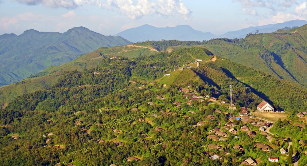
The Patkai borderlands were a ‘fluid, connected’ (p 3) transnational geographical space with a ‘diverse human landscape’ (p 2) strategically positioned between India, Burma, Tibet, and China. Their untraversed geography, coupled with dynamic ethnographic flows, complicated the settlement of a boundary between India and Burma. Historically, the region was relegated to an inconvenient territorial patchwork in the India-Burma division of 1937. It was galvanized into a military front line between the Allies and invading Japanese forces in 1942 during the Second World War, and subsequently perceived as an important buffer zone against Chinese expansionism. The protracted attempts to delimit this region were further exacerbated by the competing self-interests of the colonial officials at the centre and frontiers, as well as the expansionist ambitions and administrative concerns of the interim governments in Delhi and Rangoon and their provincial counterparts.
Guyot-Réchard delves into regional archives to bring to the fore the various boundary proposals and correspondences that transpired between various actors. The article makes a compelling case to account for the historically erased experiences of local inhabitants in these borderlands.
The recent refugee influx in India shows how notwithstanding the grand imperialist experiment of delimiting their homeland, cross-border familial and ethnic ties in the Patkai continue to prevail long after the partition between India and Burma. While New Delhi has been insistent on deporting the refugees, border states such as Mizoram have offered support, exposing the dichotomy between a top-down imposition of boundaries and the experiences of those living in borderlands.
At this juncture, a decentralised and inclusive approach to the region and its history is crucial. This is particularly relevant as New Delhi seeks to leverage the Northeast as a strategic conduit of connectivity with Myanmar and Southeast Asia under the ‘Act East’ policy. Revisiting the India-Burma partition from the lens of the those living in the periphery and extricating their narratives from historical amnesia, is therefore a fundamental step forward.
Nitika Nayar: Your article disputes the nation-state driven logic of the Patkai partition between India and Burma from the 1930s onwards. For local inhabitants, this unleashed an “unfinished and pain-ridden separation,” (p. 3) which you also describe as an “imposition” (p. 5). But you also describe Indian and British lines of thinking that pushed for a bottom-up, consultative process involving the Nagas and other Patkai groups. How did these proposals for a more flexible India-Burma border look like, and are they relevant today?
Bérénice Guyot-Réchard: In 1944-45, at the end of the Second World War, colonial frontier officials met to discuss what to do with the borderlands straddling India and Burma: the Patkai highlands. Divided piecemeal during the British Empire’s expansion, the region was a hodgepodge of administrative jurisdictions. Officials had always found it hard to manage it. Its borders were unclear and administration, problematic. More importantly, the Patkai was home to a variety of people—Zos, Nagas, Kachins, for instance—with strong connections with one another. Colonial boundaries marginalised them and pulled them apart from one another.
Why do I resurrect these forgotten boundary proposals? Because they remind us that there’s nothing natural about the division between India and Burma.
With the Allies hurtling towards victory, and India and Burma towards independence, frontier officials decided to make the Patkai’s map look right, so to speak. They proposed re-arranging its political configuration to bring each tribe (as they called local communities) under a single administration. Some favoured keeping the region as a single unit under the British Crown; the majority proposed some form of ties between the Patkai and India.
These new proposals took the Zos, Kachins, or Nagas’ lives and connections into account. But let’s not mistake them as a project that would give people control over their destiny in the era of decolonisation. Frontier officials advocating this administrative and boundary shake-up thought they were acting in the interests of the Patkai’s inhabitants; yet, they did so in a paternalistic way that reduced them to people too “primitive” (read, “innocent”) to speak for themselves. In any case, from the colonial authorities’ standpoint, the bigger issue was how to consolidate the Patkai into a buffer protecting India from a resurgent China. By and large, people were not consulted, let alone treated as the primary stakeholders—yet there were, in some areas at least, intense political mobilisations and discussions around a post-colonial future among the inhabitants.
Why do I resurrect these forgotten boundary proposals? Because they remind us that there’s nothing natural about the division between India and Burma. No matter how problematic the proposals were, they uncover the violence that came with the imposition of national borders during decolonisation—especially for places like borderlands, which are often the home of minority people.
That said, I’m doubtful that these plans for the Paktai would have solved anything, in and of themselves. You mention “a more flexible” India-Burma border in your question, but that is precisely what colonial officials in 1944-45 didn’t consider. The goal was to change the location of the border, partly by acknowledging ethnic configurations…but mostly to make it more efficient for the state’s enterprise. These frontier officials thought that the Patkai’s “very silly boundaries” (as one of them called them) could be fixed by finding the “right location” for them. They didn’t see that the very idea of a border as a fixed, dividing line was the problem. The violence and suffering Naga, Kachin, or Zo people have experienced since is partly due to this blindness. In that sense, the relevance of these old proposals lies not with their specific suggestions, but in reminding us of the limits of territorial, border-centric thinking.
NN: Your article reveals the complex human landscape of Patkai’s transnational borderlands, partitioned between two newly created independent nations. The current violence at the border between Assam and Mizoram, or the continued demands to partition Manipur show how delimitation in India’s Northeast remains a contentious issue also at the domestic level. What lessons does the Patkai partition hold for today’s internal border delineation attempts?
BGR: When we talk of “partition” we think of the creation of India and Pakistan, and secondarily of the fate of Punjab and Bengal. But Assam too (to use a shorthand for the north-eastern parts of India in 1947) was partitioned. In fact, it was partitioned repeatedly. First with Sylhet’s so-called “transfer” to East Pakistan, then, over the 1960s and 1970s, with the creation of Nagaland, Meghalaya, Mizoram, and Arunachal Pradesh.
No other part of India has experienced partition more often, in recent times, than what we now call the Northeast. Time and again, the Brahmaputra Valley and the surrounding highlands have been subjected to attempts to “right-size” them— socially, territorially, and politically. Creating new territorial entities (not just new states, but also autonomous districts) is a way to protect the Indian state’s perceived security interests. The goal is to placate demands for change, notably by co-opting restive local elites.
No other part of India has experienced partition more often, in recent times, than what we now call the Northeast. Time and again, the Brahmaputra Valley and the surrounding highlands have been subjected to attempts to “right-size” them— socially, territorially, and politically.
So, the “Northeast” we see on the map was not just created through multiple divisions; it is the very manifestation of partition as a process. In South Asia at least, this logic becomes self-fulfilling: as an attempt to fix deep-rooted political, identity, and socio-economic issues, partition ends up creating the conditions of its own reproduction.
Hence the recurring tensions we’re witnessing among and within Indian states in the Northeast. Arunachal, Assam, Manipur, Meghalaya, Mizoram, Nagaland, and Tripura may be nicknamed the “Seven Sisters”, but their policemen are capable of shooting the inhabitants of a neighbouring state, and people in Assam of blocking all access to Arunachal (as happened in 2014 for instance), all in the name of retaliating against “encroachment”. Meanwhile, there are calls for yet more states to be carved out from the Northeast, from Bodoland to eastern Nagaland. That’s not necessarily because there is a strong, popular demand for them, but because creating new political entities has become the overarching logic by which state-society relations operate in this part of India.
But we need to look across the international border, at Myanmar, as well. The military coup and brutal crackdown that’s happened on the other side of the Patkai have once again put many people on the move in these borderlands, desperate for safety. From Delhi’s perspective, they are refugees who might create problems for India-Burma relations. But from the standpoint of Mizo people, for instance, the Chins finding refuge in Mizoram are kin, but kin that have been left estranged by a colonial/post-colonial border. The Patkai’s upheavals remind us that partition is a self-generative process—and that ways of thinking that privilege territory at the expense of people in the end risk running into a self-defeating circle.
NN: In another article, you recount in great detail the Patkai’s political and socio-economic transformation as a key front line during the Second World War. One lasting outcome was the construction of the Ledo (Stillwell) Road connecting India to Burma and Kunming, in China. Today, India’s concerns about China are, once again, driving investments in the borderlands to increase connectivity with Myanmar and Southeast Asia. Can we say that the development of the Patkai borderlands has been a function of New Delhi’s national security and strategic concerns?
BGR: Yes, and this way of thinking has shaped Delhi’s engagement with north-eastern India since independence. The region is simultaneously seen as the “sentinel of the nation”, protecting India from invasion from the east (in classic buffer fashion), but also as a weak link through which subversion could occur. Note, by the way, that the very name of “Northeast” is just a direction, not a word with local historical and cultural meaning.
The language of national security and strategy is also deployed by state governments, from Assam to Tripura, to induce Delhi to grant them a bigger budget and other forms of support. Already in 1950, when Bishnuram Medhi, Assam’s Chief Minister, was petitioning Delhi to dispense his state from welcoming Bengali refugees, he presented them as a national security risk and Assam as India’s security bulwark.
One thing has changed: today’s strategic concerns are just as much about trade opportunities as about military threats. The Ledo Road, built with so much loss of life it was nicknamed A Man A Mile Road, fell into disrepair shortly after the Second World War ended in the China-India-Burma Theatre. For good reason: independent India did not see it, or these borderlands generally, as a link to China, Tibet, and Burma (this was largely due to sheer ignorance of the region and its history). Instead, Nehru and his Cabinet saw the Ledo Road as a conduit for all sorts of threats, from Chinese military invasion to infiltration by Burma-based Communists to smuggled weapons and drugs. Here lies the whole dilemma with roads: they provide access, but to all sorts of things, good and bad.
Today, however, ‘geo-economics’ are just as big as geopolitics. The world’s economic centre of gravity is shifting east, in no small part because of East and Southeast Asia’s booming economies. The Northeast’s historical role as a transregional hub between India, China, Tibet, and Southeast Asia is re-emerging. Would India benefit from embracing that dimension of the region, which was long buried by the effects of partition, the imposition of national borders, and violence? Or would the building of roads intensify internal and external threats?
Delhi continues to hesitate, I think. And this is why, in part, we have yet to see grandiose plans for an India-Myanmar-Thai Highway come to life. But even if they materialise, treating the India-China-Burma borderlands primarily as “on the way to” other places, rather than as places in their own right, whose inhabitants have their own history, needs and aspirations, can only end badly.
Treating the India-China-Burma borderlands primarily as “on the way to” other places, rather than as places in their own right, whose inhabitants have their own history, needs and aspirations, can only end badly.
NN: In contrast to India and Pakistan, why have South Asia’s other partitions received such limited attention in scholarship?
BGR: There are multiple reasons for this. First, the partition of Bengal and Punjab dwarfs the others in the size of the territory divided up, the slapdash drawing of the border, and the scale of the migration, violence, and trauma it generated. The “further shores of partition”, from regions like Sindh that experienced their own traumatic forms of displacement to less directly affected ones like the South of India, have largely been afterthoughts, until relatively recently (see Ansari, 2005; Shahani, 2021).
The other problem is that our mental maps act as a straitjacket. Today, we treat India/South Asia and Southeast Asia as separate, neatly delimited, culturally distinct entities. We forget how intertwined they were, not only in regions like the Patkai but through oceanic spaces like the Bay of Bengal. It’s only recently that scholars have started asking, “can we think of the imposition of exclusive citizenship regimes or migration control between India, Burma and Malaya, following independence, as processes of partition in their own right?” To study disruption, dislocation, or partition, and dis-integration, we first need to see space and place differently (see Amrith, 2015).
Finally, in the case of the India-Burma border, our inattention to its repeated partitions is linked to the Patkai’s marginalisation within India and Myanmar’s public life, and the scholarship written about these two countries. All this to say, there’s so much more to do!
NN: As India renews its focus on promoting connectivity in the region, what, according to you, are the other unexplored, historical dimensions of the India-Myanmar border worth examining?
BGR: I hope that research on the Northeast will not just be driven by current-day concerns, especially if these concerns are determined by the Indian or Burmese centre. Otherwise, the “otherisation” and marginalisation of the India-Burma borderlands will continue.
I’m convinced there’s far more to do to recover the experiences of the Second World War in the Patkai and to study how that war bled into later conflicts in the region, notably with the Indian and Burmese centre. (This is where the battles of Imphal and Kohima took place, after all.) We also need more accounts of how the Patkai’s diverse people approached decolonisation, independence, partition, and the transition to post-colonial, national borders. I’ve attempted this in my own work and others have done so too. Jangkhomang Guite, Joy Pachuau, Mandy Sadan and Lydia Walker are only a few of them. (I also want to mention Bianca Son-Suantak, who had shown the way with her history of the Zo people before her untimely death.) But this is just a start. The most exciting thing is that there are new generations of scholars from the Northeast and in the Northeast—with linguistic skills, cultural awareness, and local engagement I can only dream of— who are pushing for it (see Guite, 2010; Son-Doerschel, 2013; Sadan, 2013; Pachuau, 2014; and Walker, 2019).
It may well get harder to do research in Burmese archives after the Myanmar coup, but that shouldn’t stop us. Writing “deep” histories of these borderlands, histories centred on its people, is essential. We live in a time where the oppression of minorities in the region, from the Chakmas to the Rohingyas, is enabled by manipulations of the past that benefit from scant historical research. Historians have a real responsibility here.
NN: You observe that both London and New Delhi generally agreed that “India’s security required a strong, united Patkai as a buffer against China.” (p. 9) What is the historical track record of buffer zones or states in preventing or managing inter-state conflict in the region you studied, in the Himalayas? Is this line of thought outdated today?
BGR: First, we need to recognise the colonial baggage that the words “buffer” or “cordon sanitaire” carry. These concepts were central to the way British Indian authorities understood space, and how they sought to control it in order to keep India under control. Afghanistan (which didn’t have control over its foreign affairs between the late nineteenth century and 1919) or Tibet (whose autonomy from Qing China the British encouraged, even as they kept it isolated) are examples of that.
That imperial logic of the buffer may have worked for a time, but I’d argue it held within it the seeds of its own destruction. Despite attempts to gain international recognition, forge diplomatic relations, and reform internally, Dalai Lama-ruled Tibet ended up woefully unprepared and diplomatically isolated when Communist China launched its annexation drive in 1949.
Tibet also shows the destructive nature of “buffer thinking” for the people who inhabit these places. To speak of a buffer is to effect one of the most immediate, sweeping acts of erasure; it creates a space not just out of place, but out of time, whose people are at best silhouettes, at worst invisible. This is very clear with Arunachal Pradesh. Its people might as well be ghosts when one reads standard accounts of Sino-Indian conflict.
So, whatever angle you take, it seems to me that the idea of buffer needs to change. My conviction is that the solution lies in recognising the fundamental reality of the India-Burma (and China) borderlands as places that people call home. At a time of climate change, when these very borderlands host some of our greatest hopes—large water resources, huge levels of biodiversity, indigenous forms of knowledge on the environment and sustainability—but also the risks associated with them, doing so seems more essential than ever.
My conviction is that the solution lies in recognising the fundamental reality of the India-Burma (and China) borderlands as places that people call home.
NN: Going beyond the National Archives of India, your research also explores the uncharted records in north-eastern states such as Arunachal Pradesh. How significant are these regional archives to debunk our conventional understanding of these borderlands?
BGR: They are crucial. Not that there’s nothing to be found in Delhi or Yangon. A lot of their documents have yet to be mined. But researching borderlands solely through centrally held archives poses multiple problems. First, there’s the issue of optics. For a century and a half at least, the Himalayas and the Patkai have been looked at from the outside, as objects of central surveillance, control, or charity. Bypassing regional archives risks furthering this tradition.
It also makes us less capable, as historians, of understanding dynamics specific to these regions (or indeed driven by them), weakening our grasp of the complex interplay of centre-region dynamics. The study of Sino-Indian relations is a case in point. Reams of books and articles have been published on why China and India went to war in 1962. My work in the archives of Arunachal Pradesh revealed, contrary to conventional wisdom, that the conflict stemmed just as much from China and India’s contest for authority and legitimacy over Himalayan people as from military one-upmanship. And this contest had much to do with borderlanders’ own actions, and the relative bargaining power they had vis-a-vis Indian and Chinese officials (see Guyot-Réchard, 2017).
The treasure trove I found in the Arunachal Pradesh State Archives is not an exception, by the way. The Northeast’s archives, both governmental and private, hold reams of material that would benefit from study. True, they can be poorly catalogued and breaking into pieces. But local archivists are doing a tremendous effort, often with little support from above or recognition from the scholarly community, to preserve them and enable their consultation. I especially want to mention the work of Kime Ampi and Nani Soli at the Arunachal Pradesh State Archives Itanagar, and the team once led by Jishnu Baruah at the Assam States Archives. Shadow States and my other work certainly couldn’t have seen the light of day without their expertise and generosity.
I want to end on this: we need more histories about the Northeast told from the Northeast. This starts with regional archives (including private ones, even more starved for funds and flying under the radar, like the Nanda Talukdar Library in Guwahati or the visual material gathered by Joy Pachchuau and Willem van Schendel for their wonderful book, The Camera as Witness). But it also means nurturing, training, funding, and enabling new generations of historians from the Northeast itself.
About the Expert

Bérénice Guyot-Réchard is a historian of South Asia and the Indian Ocean and is currently Associate Professor in contemporary international history at King’s College London. Her work focuses on the legacies of decolonisation on the world as we know it today, particularly in terms of international politics. She has written extensively on Sino-Indian relations and on the strategic borderlands between India, Tibet and Burma, most notably in Shadow States: India, China and the Himalayas, 1910-62 (Cambridge University Press, 2016). She is currently working on the geopolitics of the Indian Ocean since 1945 and on post-colonial India’s practice and imagination of diplomacy, while retaining her foothold in the Patkai and the Himalayas. Email: berenice.guyotrechard@kcl.ac.uk

Find on this page
The Centre for Social and Economic Progress (CSEP) is an independent, public policy think tank with a mandate to conduct research and analysis on critical issues facing India and the world and help shape policies that advance sustainable growth and development.