Linking Land Borders: India’s Integrated Check Posts
Reading Time: 48 minutesEditor's Note
Support for this research was generously provided by the Australian government, Department of Foreign Affairs and Trade (DFAT). CSEP recognises that the value it provides is in its absolute commitment to quality, independence, and impact. Activities supported by its donors reflect this commitment and the analysis and recommendations found in this report are solely determined by the scholar(s).
DOWNLOADS
Abstract
This paper examines the role of India’s Integrated Check Posts (ICPs) in South Asia in facilitating regional connectivity. The ICPs are entry and exit points on India’s land borders and house various facilities such as customs, immigration, border security, quarantine, among others, within a single facilitation zone. Formulated in the early 2000s in the aftermath of the Kargil War (1999) and initiated since 2012, the ICPs have helped streamline cross-border trade and passenger flows through the modernisation of border management infrastructure. In 2019-20, 40% of India’s total trade with Bangladesh, Nepal, Myanmar, and Pakistan took place through the six ICPs at Agartala, Petrapole, Raxaul, Jogbani, Moreh and Attari.
However, several challenges such as the lack of mirror infrastructure in the neighbouring countries, limitations in public-private partnership, and ground-level issues including inadequate warehousing space to handle increasing volumes, narrow approach road, lack of digitisation etc., have affected the utilisation of the ICP to its full potential. The paper delves into these challenges, both at the policy and operational level, and suggests recommendations to overcome the same. It also analyses international best practices in border management through two comparative case studies: the USA–Mexico and Norway–Sweden border check-posts. Finally, the paper argues that while ICPs are integral for regional economic integration in South Asia, the future expansion of ICPs ought to be aligned with other regional connectivity initiatives to complement the existing and envisaged economic corridors and supply-chain routes.
Keywords: Integrated Check Posts, Land Ports Authority of India, South Asia, Regional Connectivity, India’s Land Borders, Connectivity Infrastructure
Recommended citation: Sinha, R. (2021). Linking Land Borders: India’s Integrated Check Posts (CSEP Working Paper 9). New Delhi: Centre for Social and Economic Progress
India shares 15,106.7 kilometres (km) of international land borders with seven neighbours—Afghanistan, Bangladesh, Bhutan, China, Nepal, Myanmar, and Pakistan. Movement of goods and people across these borders is facilitated by different kinds of border management infrastructure, including Land Customs Stations (LCSs), Immigration Check Posts (ImCPs), consolidated facilities like Integrated Check Posts (ICPs) and other border-trade centres.[1] Of these, ICPs are important facilitation points, ideated in the early 2000s and operationalised since 2012 with the inauguration of India’s first ICP at Attari, Punjab. As of 2021, India has nine operational ICPs along its land borders with neighbouring countries, of which seven have been formally inaugurated. In 2019–20, trade worth approximately US$ 7.9 billion took place through the inaugurated ICPs, accounting for approximately 40% of India’s total land-based trade with Bangladesh, Nepal, Myanmar, and Pakistan.[2] Overall, however, trade with the neighbouring countries only accounts for 3.5% of India’s global trade.[3]
Regional economic integration in South Asia stands at an abysmal 5% (Kathuria, 2018). This share has been consistently low for years. A report by the National Transport Development Policy Committee (NTDPC, 2014, p.593) notes that such a low level of integration has roots in the lack of quality border management infrastructure, leading to high logistics cost. In South Asia, the logistics cost is very high at 13–14% of the gross domestic product (GDP), as against the global average of 8–9% (Gupta, 2018). The Covid-19 pandemic has further stressed that beyond the trade gaps that exist during normal times, there is a need to strengthen border infrastructure and its management to ensure the continuous supply of essential goods and the movement of people. For instance, at ICP Petrapole—one of the busiest land borders between India and Bangladesh—all trade and immigration activities were suspended between March and June 2020. As a result, bilateral trade volume dropped to US$ 421 million in April–May 2020, compared to US$ 2 billion during the same period in 2019 (Noyon, 2020).
The idea of developing ICPs was formulated by India to provide customs, immigration and other allied facilities through a single facilitation zone.
The idea of developing ICPs was formulated by India to provide customs, immigration and other allied facilities through a single facilitation zone. Geographically and metaphorically, the ICPs epitomise the state’s attempt to exercise central administrative control in an otherwise neglected periphery. Literature on border management in South Asia has put the primary focus on securitising the borders, with trade and travel facilitation being treated as secondary (Das, 2021). This approach rendered the South Asian region disconnected for much of the latter part of 20th century. Therefore, it is also important to analyse the role of the state in constructing and maintaining the ICPs to regulate cross-border trade and movement of people, and in turn evaluate the approach towards regional connectivity. Few studies have been conducted focusing on ICPs in the region and their role in facilitating regional integration. They have focused on ICPs within the larger ambit of bilateral trade relations (Taneja, Prakash, Bimal, Garg & Roy, 2019; De & Iyengar, 2014; CUTS, 2019). An exclusive study focused on contextualising the ICPs within the larger framework of regional integration in South Asia is lacking.
This paper aims to address the gap in the understanding of the ICPs beyond operational difficulties at the ground level and is divided into five sections.
The first section looks briefly at border management infrastructure and regional connectivity in South Asia. The following section analyses the Indian government’s approach towards establishing the Land Ports Authority of India (LPAI) and the ICPs. The paper then comprehensively maps the status of the six inaugurated ICPs in terms of infrastructure, trade, and passenger volume and identifies several challenges. The next section highlights international best practices in the cross-border movement to address the various challenges faced at the Indian ICPs, and the last section assesses the future role of ICPs within the ambit of a comprehensive border management system among the other regional connectivity initiatives in South Asia, including inland waterways, railways, etc. The paper concludes with policy recommendations.
The data on trade movement through the ICPs (2011–2020) has been sourced from the Directorate General of Commercial Intelligence and Statistics (DGCI&S), Ministry of Commerce and Industry (MoCI), Government of India. The data for passenger movement is sourced from the LPAI website.
Qualitative inputs have been collected through interviews with key stakeholders in the Government of India, former bureaucrats, scholars, and traders. All years refer to the Indian fiscal year from April to March, unless otherwise stated.
Data discrepancy was observed while analysing the trade figures for ICP Moreh with the figures reported by DGCI&S being much lower than those reported by the Ministry of Commerce, Government of Myanmar (see Ministry of Commerce, n.d.). For instance, in 2019–20, the Government of Myanmar reported trade worth US$ 96.7 million through ICP Moreh; the DGCI&S reported the same as US$ 0.2 million. The reason for this large discrepancy is unclear. To maintain consistency of data, the paper uses only DGCI&S figures. In case of exchange rates from Rs to US$, the paper uses data published by the Reserve Bank of India at nominal (current) dollar values.
It should be noted that ICPs exist on the Indian side with only four neighbouring countries. Therefore, this paper covers data between India and those neighbouring countries, namely Bangladesh, Nepal, Myanmar, and Pakistan.
Efficient connectivity infrastructure is a prerequisite for regional economic integration. A World Bank study led by Sanjay Kathuria (2018) posits that trade between South Asian countries could be close to US$ 67 billion, three times more than the actual figure of US$ 23 billion. Various structural impediments, tariff and non-tariff barriers have limited the trade potential in the region, and in turn, affected regional integration.
Following economic liberalisation in the twentieth century, countries in South Asia have prioritised trade with distant European and Southeast Asian countries but have effectively maintained a closed border within the neighbourhood. For instance, it takes approximately two days for a container to be shipped from Kolkata port to Singapore (approximately 3,700 km), whereas it takes about the same amount of time for a truck at ICP Petrapole to cross the land border into neighbouring Bangladesh. Till the early 1960s, India, Nepal, and formerly East Pakistan (Bangladesh) were well connected through the waterways of Ganga and Brahmaputra rivers, and a large number of active rail services. Regional air connectivity in South Asia has also decreased significantly, with no flights between Nepal and Pakistan, or between smaller cities such as Port Blair (India) and Yangon (Myanmar) (Xavier & Sinha, 2020).
As a result of this poor state of connectivity, which affected the region for decades, little attention had been given to improvements in border management infrastructure till the 1990s.
Evolution of India’s border management infrastructure
The push for improving land border management infrastructure began in India in 2000, in the aftermath of the Kargil War (1999). This led to the institutionalisation of border management through the establishment of the Department of Border Management in January 2004 under the Ministry of Home Affairs (MHA, 2004). During this time, a security-oriented approach to border management was dominant, and discussions were held by a Group of Ministers on the setting-up of border management infrastructure to check illegal activities.[4]
At the India–Nepal border, the Group recommended setting up ImCPs and LCSs at all transit points linked to Kolkata Customs, in order to check the illegal movement of people and goods; between India and Bangladesh, the Group called for ‘renewed efforts’ to formalise cross-border trade and check smuggling; and for the India–Myanmar border, it recommended the establishment of ‘a composite check-post’ at Moreh. It would comprise customs and immigration facilities and be manned by staff from the federal Narcotics Control Bureau and the State police (Group of Ministers, n.d., pp. 65-68).
In the last decade, several other factors have also led to further modernisation of border management infrastructure through the establishment of ICPs. First, the rising trade between India and its neighbouring countries, the increasing volume of literature on the potential of economic corridors in the region, and the shifting focus among governments on using the South Asian countries as transit corridors—have all spurred further growth (De & Iyengar, 2014).
For most Least Developed Countries (LDCs) in South Asia, trade is at the heart of economic development. India is the market for approximately 70% and 90% of Nepal and Bhutan’s exports, respectively. Since the 2000s, India’s trade with Nepal has increased from US$ 0.3 million in 2000–2001 to US$7.9 billion in 2019–20.[5] Furthermore, approximately 75% of Nepal’s and 100% of Bhutan’s global trade transits through India (Sinha & Sareen, 2020). These rising trade volumes necessitate improvement in border trade infrastructure.
Secondly, this is also driven by China’s growing investments in infrastructure in South Asia (Xavier, 2020). India has been taking steps to correct decades of regional insularity with a focus on increasing connectivity with its neighbours, both at the regional and bilateral level. In this regard, the need to improve border management infrastructure was identified in the 2000s. This approach further accelerated under the ‘Neighbourhood First’ policy initiated in 2014, wherein improving regional connectivity infrastructure became a policy priority. According to the Ministry of External Affairs (MEA, 2019), this policy places neighbouring countries in the ‘first circle of priority’ and is based on the tenets of ‘connectivity, commerce, and contacts.’
The development of the ICPs in India and its immediate neighbours is one of the key focus areas to improve connectivity. The ICPs in Northeast India are also important for the nation’s Act East policy.
The development of the ICPs in India and its immediate neighbours is one of the key focus areas to improve connectivity. The ICPs in Northeast India are also important for the nation’s Act East policy, which is an extension of its 1991 Look East policy and is focused on integrating the Indian economy with the supply chains of Southeast Asia (MEA, 2021). Both policies have also led to the setting-up of mechanisms for monitoring infrastructure projects with neighbouring countries. For instance, after Prime Minister Modi’s visit to Nepal in 2016, a Nepal-India Oversight Mechanism was put in place to oversee the implementation of bilateral projects (Roche, 2020).
Finally, improving cross-border trade infrastructure is also driven by India’s international obligations. In April 2016, India ratified the World Trade Organisation’s Trade Facilitation Agreement (TFA), thus committing to simplification and harmonisation of trading across borders. India has also formulated a National Trade Facilitation Action Plan 2020–2023, to reduce the time it takes to release cargo from ports. The National Committee on Trade Facilitation (NCTF, 2020) set the target for clearance of goods from an LCS within 48 hours for imports and 24 hours for exports, by enabling paperless transactions and infrastructure augmentation. Particularly for land ports, the action plan includes upgrading the identified LCS’ to ICPs; resolving issues related to logistics and infrastructure (with a specific focus on the LCS in the Northeast); and standardising operational procedures in terms of working hours and labour charges. Additionally, in 2017, India also ratified the Transports Internationaux Routiers or International Road Transports (TIR) Convention.[6] By joining the convention, the Government of India envisaged that ‘the need for inspection of goods at intermediate borders as well as physical escorts en route shall be obviated due to reciprocal recognition of Customs controls’ (Press Information Bureau [PIB], 2017). It is also expected that the TIR Convention will help India in implementing the TFA. However, among India’s neighbours, only Pakistan and Afghanistan are signatories to the convention.
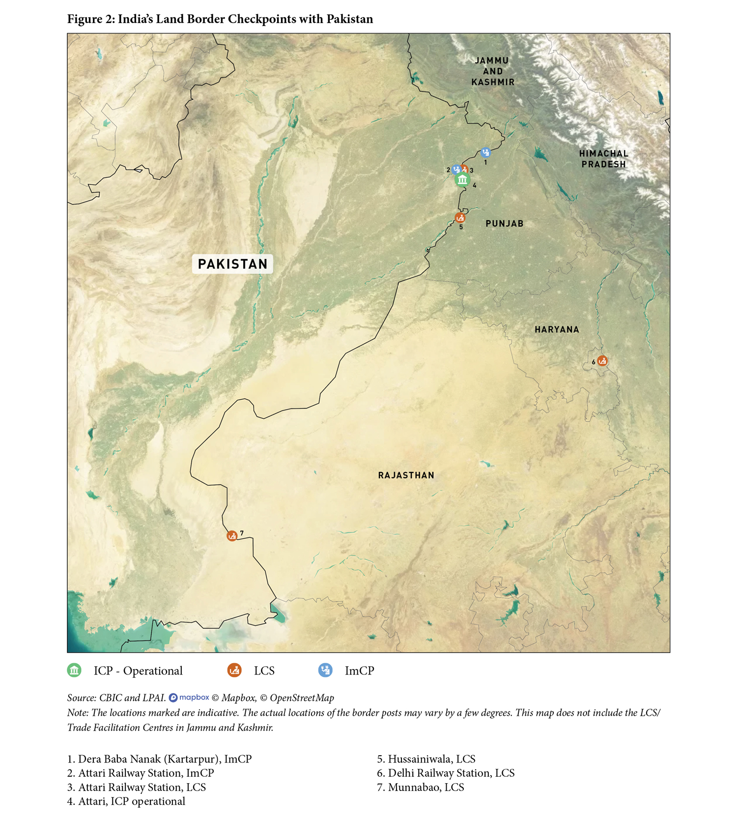
Since 2012, India has inaugurated seven ICPs at Attari, Kartarpur, Agartala, Petrapole, Raxaul, Jogbani, and Moreh. Out of these, Kartarpur is currently limited to passenger movement. India has also been constructing ICPs at Rupaidiha (Uttar Pradesh), Dawki (Meghalaya) and Sabroom (Tripura).
The ICPs are central to India’s connectivity plans in the region. They not only consist of border infrastructure for facilitation of trade and people, but also act as important centres to advance other multi-modal intra- and inter-regional connectivity initiatives, such as improving rail connectivity; implementing the Bangladesh–Bhutan–India–Nepal Motor Vehicles Agreement (BBIN-MVA); the use of Chattogram and Mongla ports in Bangladesh to transport cargo to India’s north-east region; and the Kaladan Multi-modal Transit Transport Project to connect Southeast Asia to South Asia, among others.
Land-border crossings
Land-border crossings between India and its neighbouring countries are under two categories—Land Customs Stations (LCSs) and Immigration Check Posts (ImCPs). The ICPs consolidate both facilities within a single facilitation zone. This paper primarily discusses ICPs.
All LCSs fall under the Central Board of Indirect Taxes and Customs. Chapter III (7) of The Customs Act 1962 defines it as: ‘the places which alone shall be land customs stations for the clearance of goods imported or to be exported by land or inland water or any class of such goods’ (CBIC, 1962). The LCSs are thus border crossings where trade in goods occurs between India and its neighbours.
The ImCPs are nodal points for facilitation of passenger movement across India’s land, sea, and air borders. India has 86 ImCPs, of which 37 are manned by the Bureau of Immigration (BoI), under the Ministry of Home Affairs and the remainder by state governments (Bureau of Immigration, n.d.).
Integrated Check Posts (ICPs)
The LPAI is the nodal agency for construction, operation, and management of the ICPs. It defines them as ‘major entry points on India’s land borders which … house all the regulatory agencies like Immigration, Customs, Border Security etc. together with support facilities in a single complex equipped with all modern amenities and serves as a single window facility.’ (LPAI, n.d.[a])
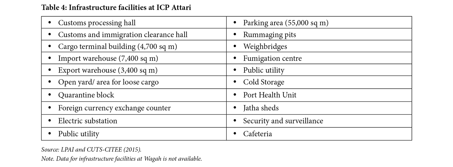
A customs station at an ICP performs the same functions as it does at an LCS, albeit with better infrastructure. At each ICP, the LPAI provides facilities such as a passenger terminal building, currency exchange, a building to process cargo, cargo inspection sheds, warehouse/cold storage facilities, a quarantine laboratory, banks, and scanners. (LPAI, (n.d.)[b])
Several stakeholders play a key role in the functioning of an ICP. In addition to the LPAI, there are six main stakeholders including Customs; immigration authorities (including the BoI or state government immigration officers); the security establishment such as the Border Security Force (BSF), Indo-Tibetan Border Police (ITBP), Seema Suraksha Bal (SSB); FSSAI, Plant Quarantine (Ministry of Agriculture and Farmers Welfare); Animal Quarantine and Certification Services (Ministry of Fisheries, Animal Husbandry and Dairying); and Port Heath Unit (Ministry of Health and Family Welfare). Coordinated management between these authorities is key to the efficient functioning of the ICPs.
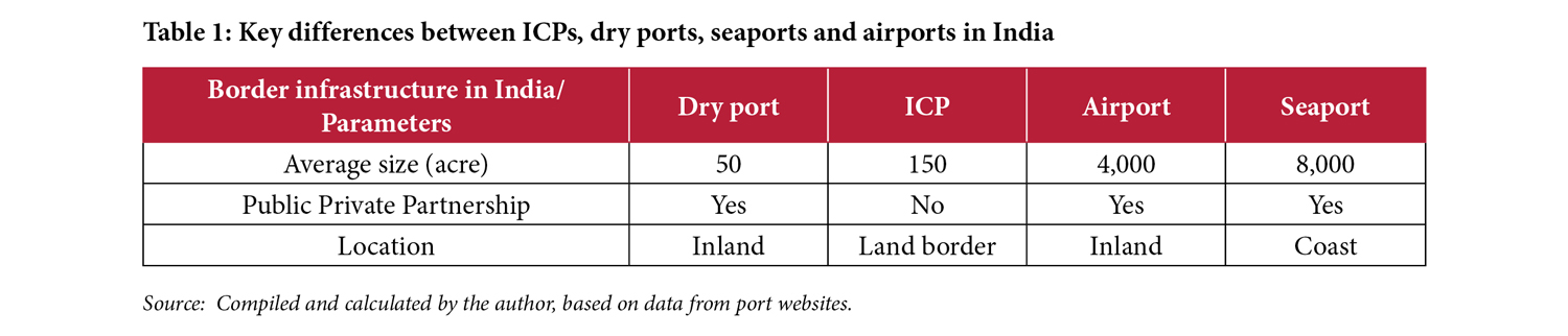
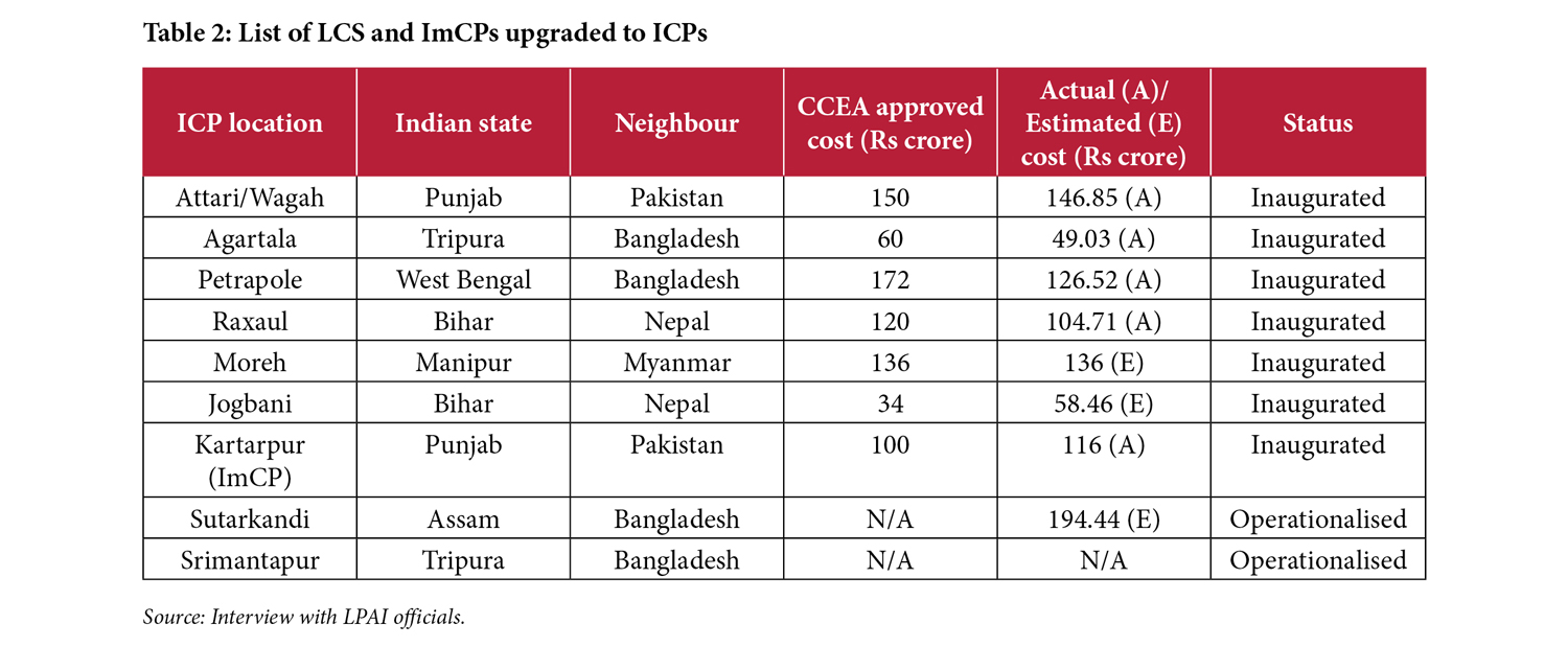
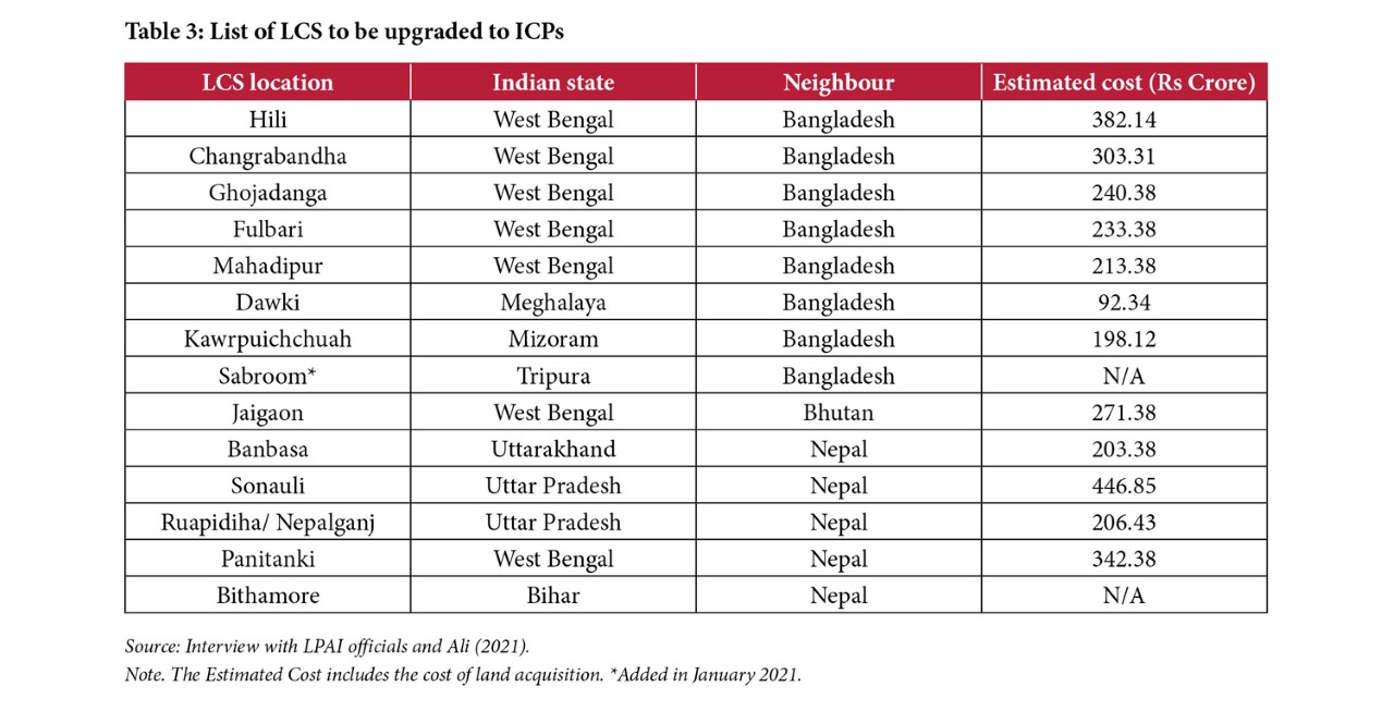
Compared to seaports and airports, the ICPs are relatively smaller ports built at a cost up to Rs 200 crore (approx. US$ 29 million). Table 1 compares the size, management, and location of different types of ports in India. In June 2006, the Additional Secretary (Commerce) had identified 13 LCS to be upgraded to ICPs at an inter-ministerial meeting based on the volume of trade. Of these, six have been completed and inaugurated (Table 2; Department-Related Parliamentary Standing Committee on Home Affairs [PSCHA], 2010).
In 2018–19, the government decided to do away with the phase-wise development of ICPs and instead prioritised development based on freight and passenger volume (LPAI, 2019). According to an official at the LPAI, the goal is to have 23 ICPs on India’s land borders by 2025.[7]
Given that less than 2% of India’s global trade takes place through the ICPs (thereby generating lesser revenue), limited emphasis has been laid on its expansion and further development till recently. In comparison, 70% of India’s trade-by value and 90%-by volume, takes place through seaports built over much larger areas than the ICPs (see Table 1). Trade of mostly high-value-low-volume commodities, such as gold, passes through airports. Compared to India’s global trade, India’s trade with neighbouring countries is in low-value goods.
Genesis: Institutionalising the ICPs
As mentioned in the previous section, the initial prompt for modernising border management infrastructure was the Kargil War between India and Pakistan in 1999. On July 29, 1999, post the war, the Government of India appointed a Kargil Review Committee (KRC) to comprehensively assess the borders and problems in national security (Godbole, 2014). Following the submission of the KRC’s report, Prime Minister Atal Bihari Vajpayee set up a Group of Ministers on April 27, 2000, to review these recommendations. The Group noted that beyond the armed security approach, a wider range of measures would be required to safeguard national security. As a result, four task forces were set up on May 16, 2000: (i) Intelligence Apparatus; (ii) Internal Security; (iii) Border Management; and (iv) Management of Defence. (Group of Ministers, n.d., pp. 1-3).
In 2004, a Committee of Secretaries directed the newly created Department of Border Management to set up an Inter-Ministerial Working Group (IWG) to consider the creation of an autonomous body that would oversee the construction, management, and maintenance of ICPs (LPAI, n.d.[a]). The IWG recommended setting up of the LPAI as a statutory body answerable to the Department of Border Management. Pending the institutionalisation of the LPAI, an Empowered Steering Committee (ESC) was formed on December 15, 2006, with representation from the MEA(MHA, 2008, p. 32). The ESC was mandated to engage with consultants (technical and commercial) and project developers, arrange funds, monitor Draft Project Reports, coordinate with the government, and take administrative and financial decisions for proposals involving expenditure up to Rs 100 crore (approx. US$ 22 million).
The Cabinet Committee on Security approved the setting up of LPAI ‘in principle’ at a meeting held on November 23, 2006 (LPAI, n.d.[a]). It was initially suggested that the ICPs be developed under the public-private partnership (PPP) model. However, the Cabinet Committee on Economic Affairs (CCEA), during a meeting held on November 6, 2008, noted that there may be concerns about sovereign functions on ‘strategically sensitive borders, and procedures related to PPP would require a substantial completion time’. Therefore, the CCEA approved a proposal that the ICPs would be constructed solely with government funding, while either the LPAI or the ESC could assign non-sovereign functions to a private entity. The 11th Five-Year Plan earmarked approximately Rs 635 crore (approx. US$ 158 million) for development of the ICPs (see Table 2; PSCHA, 2010, p. 11).
The Land Ports Authority of India Bill, 2009 was introduced in the Lok Sabha on March 9, 2009. It was referred to the Department-Related Parliamentary Standing Committee on Home Affairs (PSCHA) by the Chairman, Rajya Sabha on September 14, 2009 (MHA, 2009, p. 31). The members of the Committee held a meeting in December 2009 and sought time to examine the critical aspects of the Bill before presenting it to the Rajya Sabha on the first day of the budget session of Parliament in 2010 (PSCHA, 2010, p. 13).
The Committee highlighted various important issues, including those related to the jurisdiction of the LPAI and the ICPs, questioning the role of the MHA in instituting a body that would build infrastructure for facilitating cross-border trade and commerce, rather than the Ministry of Commerce and Industry (ibid., p. 14). Based on the Committee’s recommendations, the LPAI Bill was passed with a few amendments (including a change in the long title, plus amendments to the role of private players) to include security imperatives, trade facilitation, membership of the LPAI from different ministries, and replacement of the word ‘regulate’ with ‘coordinate’ (ibid., p. 38).
The Bill became The Land Ports Authority of India Act, 2010, upon receiving assent from the President of India, and was notified in the Gazette of India, Extraordinary, Part II, Section I on September 1, 2010 (MHA, 2011, p. 47). After selection of members, the LPAI was established on March 1, 2012, just a month prior to the operationalisation of the first ICP at Attari (MHA, 2013, p. 39).
India–Pakistan: ICP Attari
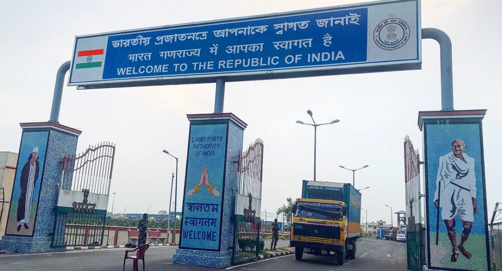
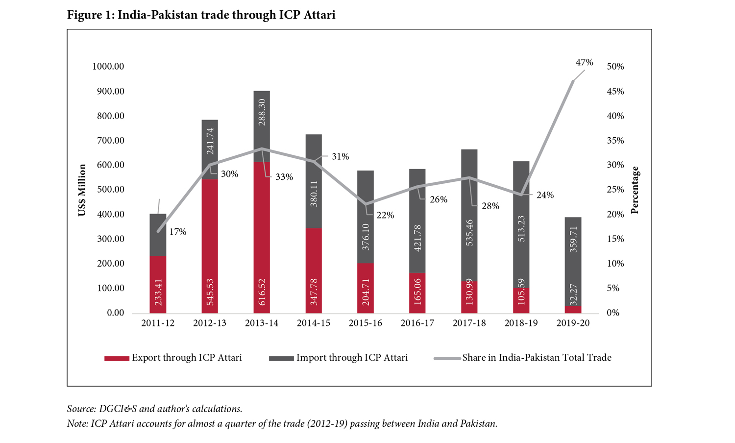
Spread over approximately 118 acres in Attari in Punjab, the ICP was built at an estimated cost of Rs 150 crore (approx. US$ 31 million) (Table 1) and borders Wagah in Pakistan. The custodian of the terminal is the Central Warehousing Corporation (CWC). It is the only road-based trading point between India and Pakistan and was the first Indian ICP to be operationalised on March 23, 2012 (LPAI, n.d.[c]; see Figure 1). It was expected that with the operationalisation of this ICP, the Attari border would become a trading hub (Mehdudia, 2012).
During the Fourth and Fifth Technical Level Meetings between India and Pakistan, held in November and December of 2011 at Attari/Wagah, India also proposed the construction of an ICP terminal at Wagah in Pakistan, however, the proposal did not materialise (MHA, 2012, p. 56).
The operationalisation of ICP Attari was one of the steps taken to normalise and boost economic relations between India and Pakistan in 2012. At this time Pakistan had a ‘negative’ list of 1,209 items that that it did not permit the import of from any trading point with India (Pandher, 2012). As per a joint statement released after the seventh round of talks on ‘Commercial and Economic Cooperation’ between the commerce secretaries of India and Pakistan in September 2012, Pakistan committed to burying the negative list within a year; however, the negative list continues to be a barrier in trade (MoCI, 2012).
Through ICP Attari, Pakistan allows the import of only 138 items, while permitting unrestricted exports to India (LPAI, n.d.[c]). India does not have any limitations on the number of items for trade from this route. As a result of the restrictions in bilateral trade through the land route, sea is the dominant mode of trade. The ICP is also used for transit of goods from Afghanistan to India.
Trade
Attari was selected as the site for the ICP based on the trade volume passing through the erstwhile LCS. Approximately 100–150 trucks crossed the border daily till late 2000s, for trade that accounted for approximately Rs 1,500 crore (approx. US$ 316 million) (Pandher, 2012). Of the total bilateral annual trade between India and Pakistan in 2011–12, around 17% took place through the Attari road route. Post inauguration of the ICP, this share increased to 30% and 33% in 2012–13 and 2013–14 respectively, with more than 250 trucks crossing the border per day (Figure 2). However, it is pertinent to note that the initial increase in trade through ICP Attari was on account of re-routing the existing trade, as the overall trade between India and Pakistan remained nearly the same.[8]
Despite reduction in the overall India-Pakistan trade over the years, ICP Attari remained an important trading point for both countries, accounting for a quarter of the trade passing between India and Pakistan (2014–2018), and almost 47% in 2019–20.
India’s major items of export include cotton, organic chemicals, tanning or dyeing extracts, plastics and articles thereof, etc. It imports mineral oils and products of their distillation, edible fruits and nuts, salt, sulphur, earth and stones, oil seeds, etc. from this port.
Passenger movement
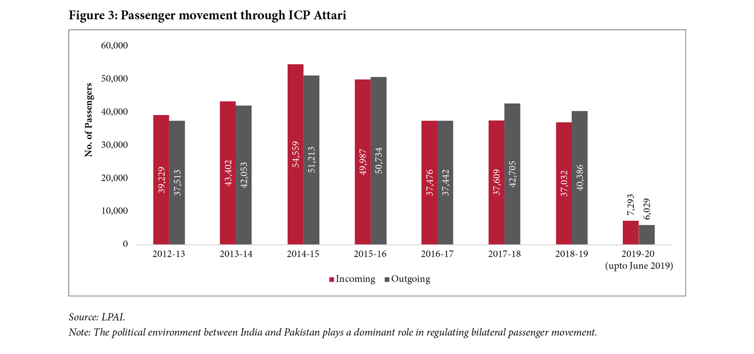
Following the inauguration of the ICP, passenger movement also increased, showing a rise between 2013 and 2016 when compared to 2012–13 (Figure 3). It must be noted that between India and Pakistan, infrastructure plays a limited role in augmenting passenger movement between both countries due to restrictions imposed by the political environment between both countries. People who received visas were mostly pilgrims or business people. Post the outbreak of Covid-19, passenger movement from the ICP was suspended between March 16 and April 15, 2020 (Ministry of Health and Family Welfare [MH&FW], 2020).
Infrastructure
Given the sensitive nature of the India-Pakistan border, the security infrastructure at ICP Attari includes CCTV cameras and observation towers manned by BSF personnel. It is the only ICP to have a full-body truck scanner, however, this is not operational. In 2017, the customs also acquired modern hand-held scanning equipment from Israel (three I-scan detectors and four video boroscopes) to check passenger baggage and truck cavities (Bassi, 2017).
Challenges
- Resumption of trade through ICP Attari: Economic relations between India and Pakistan have remained hostage to the volatile political relations between the two countries. After the Pulwama attack in February 2019, India rolled back the ‘Most Favoured Nation’ (MFN) status it had given to Pakistan and declared a tariff hike of 200% on all imports from Pakistan (Suneja, 2019). After the abrogation of Article 370 from the erstwhile state of Jammu and Kashmir in August 2019, Pakistan unilaterally ceased trade with India. While the opening of ICP Attari increased trade through this route and led to development in the nearby areas, its closure in 2019 has adversely affected the livelihood of many (Doval, 2020).
- Need for mechanised cargo-handling infrastructure: The labour-intensive loading and unloading of goods from trucks at ICP Attari increases the turn-around time of trucks at the ICP. There is a lack of equipment such as conveyor belts and cranes for handling cargo such as cement bags in the warehousing area (Sinha et al., 2016, p. 100). The current suspension of trade through this ICP can be used to upgrade its infrastructure.
- Lack of coordination between various authorities: Since its inauguration, the long-term presence of an LPAI official has been lacking at ICP Attari. Given that the LPAI’s mandate is to coordinate between different authorities, the absence of an LPAI official creates issues between the various agencies—customs, CWC, BSF, etc.—and addressing issues takes a longer time (ibid.).
- Digitisation of operations: ICP Attari is equipped with some of the most modern security equipment, including a full-body truck scanner. However, in practice, the security and customs procedure, at times, includes manual frisking of goods and passengers. Given new emergencies such as Covid-19, it is now all the more important to completely digitise the security infrastructure and streamline procedures at the ICP. Additionally, the Land Port Management System (LPMS), equipped with Radio-Frequency Identification (RFID) facility for trucks, needs to be made operational soon to digitise interactions at the ICP completely. [9]
India–Bangladesh
India shares its longest land border with Bangladesh over 4,097 km. Strong infrastructure at this border is essential for two reasons: Bangladesh is India’s largest trading partner in South Asia and it is the highest global source of tourism exports for India (Sinha & Sharma, 2020). A large quantum of trade and tourism between India and Bangladesh takes place through the land routes.
The bilateral trade is guided by the 2015 India–Bangladesh Treaty of Trade. Under Article VIII of the treaty the two countries ‘agree to make mutually beneficial arrangements for use of their waterways, roadways, and railways for commerce … and for passage of goods between two places of one country and to third countries’ (MEA, 2015). Land routes (road and rail) account for approximately 75% of India’s exports and 50% of its imports with Bangladesh (Bhattacharjee, 2019). There are approximately 38 land-border crossings (operational and non-operational), including LCSs, ImCPs and ICPs, along the India-Bangladesh border for facilitation of cross-border movements. The first ICP was inaugurated in Agartala (Tripura) in 2013, followed by Petrapole (West Bengal) in 2016. Two more ICPs have been made operational since 2020 – ICP Srimantapur (Tripura) and ICP Sutarkandi (Assam); these are yet to be inaugrated (Figure 4)
The passenger movement between India and Bangladesh is guided by the 2013 and 2018 Revised Travel Agreements. Approximately 70% (2018) of the registered tourist arrivals in India from Bangladesh are via land (Sinha & Sharma, 2020, p. 11).
In Bangladesh, trade through land ports is managed by the Bangladesh Land Ports Authority (BLPA) established in 2001, which functions under the Ministry of Shipping. While 23 LCS’ in Bangladesh have been declared land ports, the BLPA directly manages five (Benapole, Bhomra, Birumari, Akhaura and Nakugaon). The others are operated by private terminal operators on a Build-Operate-Transfer (BOT) basis (BLPA, n.d.). The BLPA operationalised the check posts at Benapole and Akhaura in 2002 and 2010, respectively.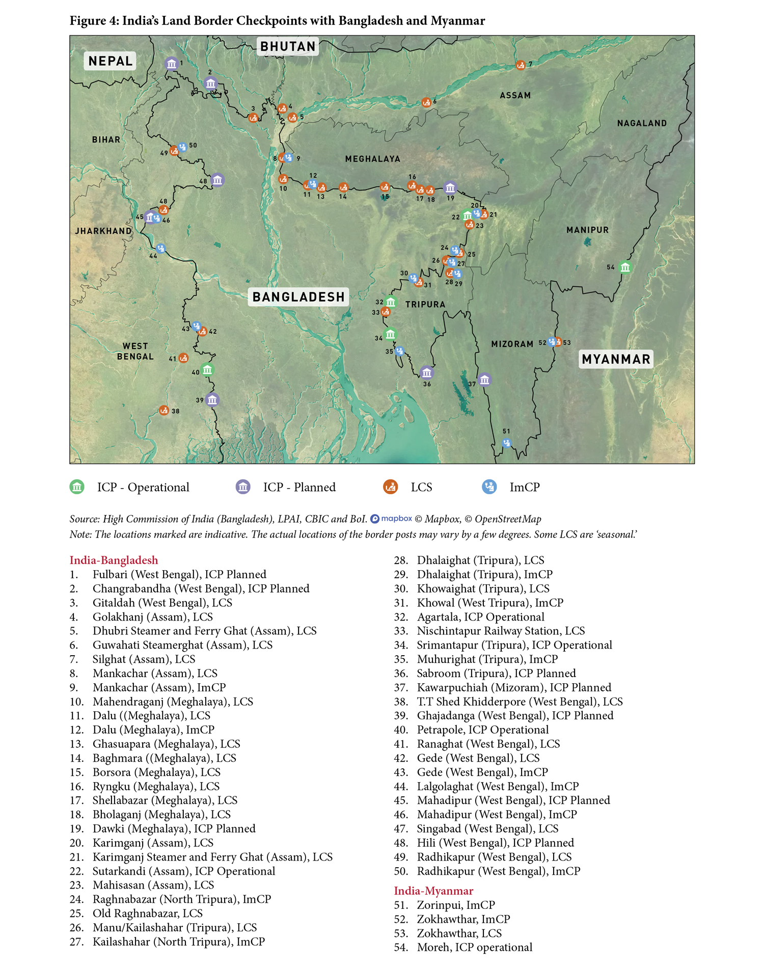
ICP Agartala
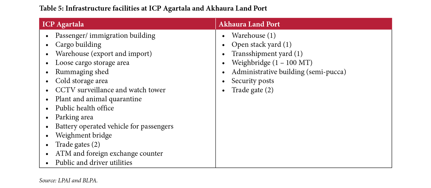
Spread over a land area of 11.72 acres, the ICP at Agartala in Tripura is the only one located in a state capital (LPAI, n.d.[d]). It was inaugurated on November 17, 2013. The corresponding land port in Bangladesh is Akhaura. It is one of the busiest routes for movement of goods and people between the two countries. The Central Warehousing Commission (CWC) was appointed as the cargo terminal operator of the ICP post inauguration. The infrastructure was built at a cost of Rs 73.50 crore (approx. US$ 13 million) (Sanyal, 2018).
Trade
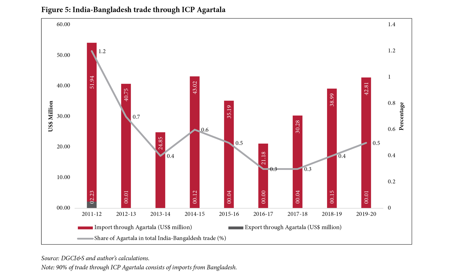
In 2019–20, trade worth US$ 43 million took place from ICP Agartala (Figure 5). This route is dominated by imports from Bangladesh, which accounts for around 90% of the trade through the port. While the trade share of the ICP has reduced over the years, from 1.2% in 2011–12 to 0.3% in 2016–17, it is again showing an increase post the inauguration of the ICP.
The main items of import by India include processed stone, bricks, tiles, fish, cement, and furniture. Whereas India exports bamboo, turmeric, ginger, marble, fruits, among other items, through the ICP.
Passenger movement
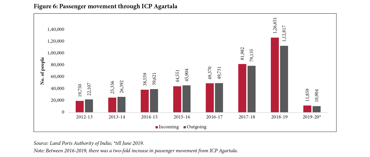
ICP Agartala records high passenger movement annually. Between 2016 and 2019, it saw a 142% increase in passenger movement (from 99,101 in 2016–17 to a record high of 2,39,468 in 2018–19; see Figure 6). This increase is arguably attributed to the Revised Travel Arrangement between India and Bangladesh in 2018. The state government mans the immigration at the check post within the ICP. On January 20, 2020, the Government of Tripura floated a tender for constructing a tourist information centre at the ICP (TTDCL, 2020).
Infrastructure
ICP Agartala is spread across 11.72 acres, and the Akhaura Land Port (Bangladesh) is 15 acres. Given the high volume of imports, the ICP has a storage capacity to 4,000 tonnes for imports and 2,000 tonnes for exports, in addition to a 7,000 sq m open yard (Sanyal, 2018). At Akhaura, the storage capacity is 2,000 tonnes (BLPA, n.d., p. 3).
Challenge
- Inadequate representation of PGAs: Food products are a major item of import from ICP Agartala. Partner Government Agencies (PGAs) such as plant and animal quarantine are present at the port. However, there is no representation from FSSAI. As a result, some food products are held for more than 48 hours at the port, adding to the time and cost of trade. There is a need to develop a network of private laboratories in and around Tripura to address this challenge.
ICP Petrapole
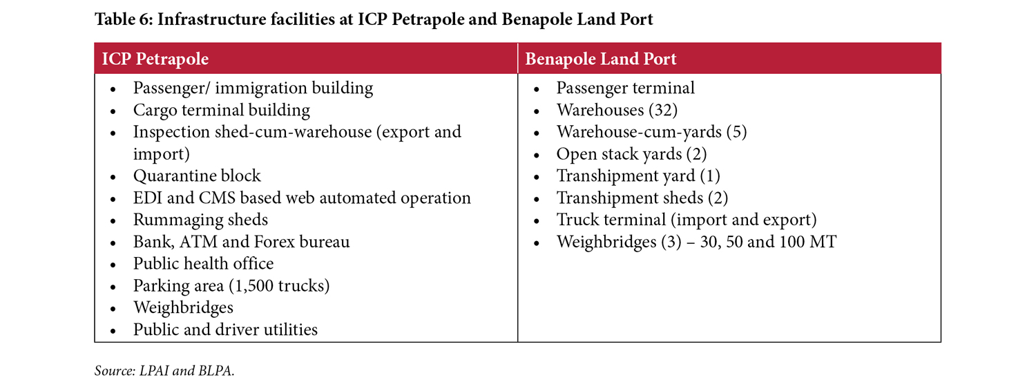
ICP Petrapole is located approximately 80 kms from Kolkata, the capital of the Indian state of West Bengal. The foundation stone for the ICP was laid in 2011 and the ICP was operationalised in February 2016. It was formally inaugurated in July 2016 (MEA, 2016). Benapole is the corresponding land port in Bangladesh. The cargo terminal at ICP Petrapole is managed by the CWC, whereas that at Benapole is directly managed by the BLPA (BLPA, n.d., p. 3).
Prior to its operationalisation as an ICP, Petrapole was functioning as an LCS with a number of issues, including limited parking for trucks. The space available was for 250 trucks at the CWC parking space, whereas the need was for at least 450 trucks. Regular congestion at the approach roads, inadequate monitoring facilities leading to pilferage, inadequate storage space, and lack of testing laboratories were some of the other issues faced at the LCS (Sinha et al., 2016). Some of these issues were addressed post operationalisation of the ICP.
Trade
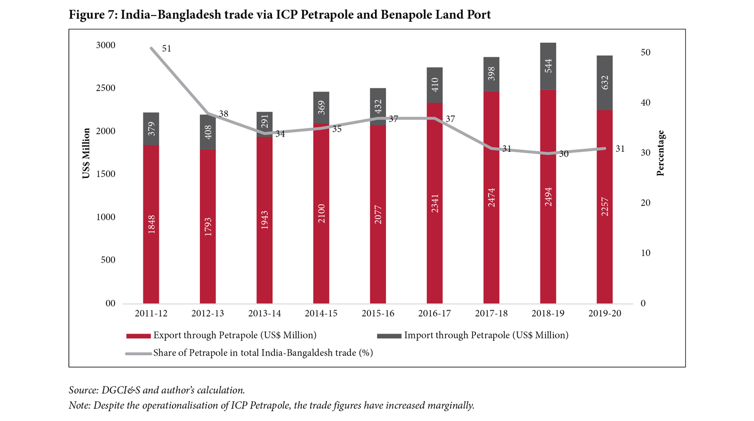
The Petrapole–Benapole route accounts for almost 65% of the land-based trade between India and Bangladesh (2019–20; Figure 7). Post the inauguration of ICP Petrapole, there was a marginal increase of 6% to 10% in total year-on-year trade through this route (2016–19). The success has been limited due to the fact the Benapole does not have mirror ICP facilities and continues to face infrastructure issues, thus limiting the total number of trucks that can cross the border in a day. According to an Indian government official, the growing trade deficit between India and Bangladesh is another factor limiting trade through the Petrapole-Benapole land border.[10] A daily average of 750 trucks cross the border for imports and exports (2018–19).[11]
Passenger movement
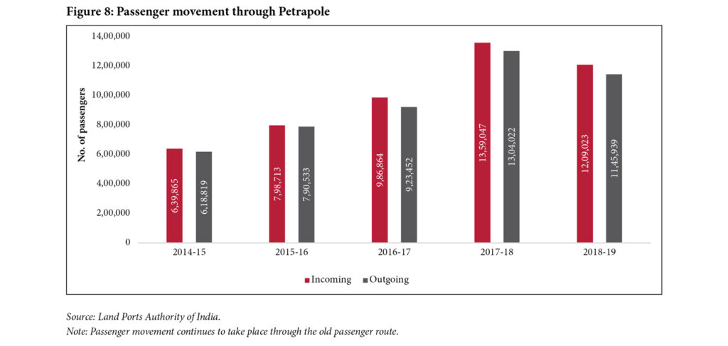
Due to its proximity to Kolkata, approximately 2.5 million people utilise the Petrapole–Benapole route for cross-border movement annually. The figures have been increasing annually (Figure 8). Currently, the passenger movement takes place through a temporary structure near the zero gate of the ICP. Construction of a new Passenger Terminal Building (PTB) commenced in February 2020 and is scheduled to be completed by May 2022. The new PTB is spread over an area of 14.55 acre (58,900 sq m).
Infrastructure
Benapole Land Port is spread over 61 acres and has a storage capacity of 40,000 MT. Given its current infrastructure (Table 8), the port has the capacity to handle approximately 2 million MT annually and is currently operating at a 110% capacity (BLPA, n.d.).
Challenges
- Heavily congested approach road: There is heavy congestion on the highways (national highways (NH) 19, 112 and state highway (SH) 1) leading from Kolkata to Petrapole. The three routes are lined with trees of high ecological importance, making it impossible to cut down and pave way for wider roads. This has also given rise to dense illegal settlements along the highway.[12]
- Prevalence of informal parking at Kalitala, West Bengal: While Indian export trucks are supposed to be parked at the ICP, an illegal parking syndicate exists approximately 20 km before the ICPs, affecting the seamless movement of cargo. A per-day parking fee is charged and trucks are parked there for 10 to 20 days. The problem has been persistent for many years (Raja, 2020).
- Lack of adequte manpower: In 2017, India and Bangladesh had agreed to operate Petrapole and Benapole border posts round-the-clock to cater to the increasing traffic (The Hindu, 2017). However, according to ground reports, the trade does not take place at night and is closed on Fridays. The problem is also persistent due to the lack of adequate customs human resources to clear the goods at the ICP round the clock.
- Paucity of parking and storage space at Benapole: Benapole is currently operating at an over-capacity in terms of cargo volume and the number of trucks it receives annually. Particularly during the border closure in 2020, due to the spread of the Covid-19 pandemic, the check-post was heavily congested with delays of up to about 10 days. While the port has 32 sheds with a total capacity of 50,000 tons, it is handling 100,000 tons (Raja, 2020b). As a result, the turn-around-time of trucks is very high, leading to high parking fees.
- Manual documentation system: Due to the lack of digitisation at the ports, many documents are handled in a physical form. For instance, the Customs Out of Charge (OOC) is signed manually by a customs officer, and the car pass is issued in triplicate physical copies endorsed by the customs and the border security agencies.[13] While many seaports have automated such procedures, the land ports continue to use the physical form of documentation. This issues are expected to be addressed once the Land Port Management System is operational.
India–Myanmar: ICP Moreh
India and Myanmar share a 1,063 km-long border in the north-east region through which cross-border movements take place. The India–Myanmar trade agreement was signed in 1970. The bilateral trade between both countries is approximately US$ 1.3 billion (2019–20), dominated by a trade surplus from India.
India and Myanmar had signed a border trading agreement in 1994, recognising two operational border trading points—Moreh–Tamu and Zokhawthar–Rhi. These trading points would be used to barter locally produced commodities and 22 items were initially listed. This list was subsequently upgraded with the addition of 18 commodities in 2008 and another 22 commodities in 2012. In 2008, both countries also agreed to upgrade the border trade to a normal trade and set up a third border trading point at Avakhung–Somna (Export-Import Bank of India, 2018).
In 2015, however, Reserve Bank of India abolished barter trade; henceforth, all trade transactions with Myanmar would be settled in any permitted currency in addition to the Asian Clearing Union mechanism.[14] As a result of the normalisation of trade, the unilateral Duty-Free Tariff Preference (DFTP) Scheme of India and the ASEAN–India Trade in Goods Agreement (AITGA) became relevant in case of Myanmar (ibid.).
ICP Moreh
Inaugurated in January 2019, ICP Moreh (India) has now become the most important border check-post along the Indo-Myanmar border. Tamu, its corresponding location in Myanmar does not operate as an ICP (Figure 4). ICP Moreh is spread over a total area of 38.34 acres and was constructed by RITES at a cost of Rs 130 crore (approx. US$ 20 million); Moreh and Tamu are located along the Asian Highway-1.[15]
The Detailed Engineering Report (DER) to set up the ICP at Moreh was approved in FY 2009–10. However, after facing several delays due to land acquisition and completion of facilities, the ICP was only inaugurated nine years later, in 2019.
Trade
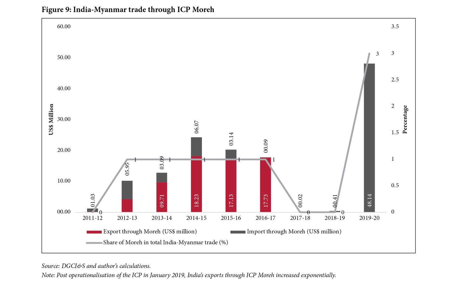
Trade through ICP Moreh ranges between 1% to 3% of the total bilateral trade between India and Myanmar. Following the operationalisation of the ICP in 2019, India traded the highest volume of exports through the ICP of US$ 48 million (Figure 9). However, it can be seen from the figure that post the 2015 ban on barter trade, the trade figures dipped. Evidently transition to formal trade was not easy due to, among other factors, the limited capacity of traders who could fulfil the new trade norms (Dutta, 2019). Lack of infrastructure for trade such as a proper road, bridges, warehouses etc., were additional factors limiting the trade.
While India’s imports through this land post have been low, they came to a halt between 2017 and 2019 after India increased import duty on betel nut, from 4% to 40%, in January 2017. The trade resumed thereafter. Today, Indian exports are mostly related to Indian projects in Myanmar (Bose, 2018).
The major commodities exported by India to Myanmar through Moreh include cumin seeds, wheat flour, pulses, coon yarn, auto parts, soyabean meal, pharmaceuticals, and dry grapes. The major items of import include betel nut, dry ginger, fresh ginger, mung, black matpe, turmeric roots, resin, and medicinal herbs, among others.
Passenger movement
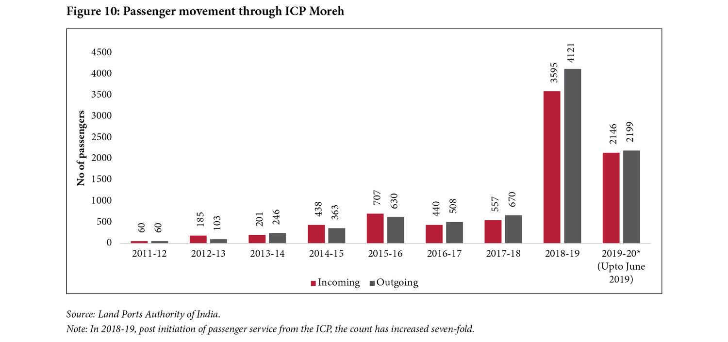
Following the inauguration of the passenger terminal building at ICP Moreh in 2018 (LPAI, n.d.[h]), passenger movement increased sevenfold in 2018–19 (Figure 10). In addition, India has since initiated gratis visas for the citizens of Myanmar. Citizens of both countries are allowed to travel up to 16 km inside each other’s territory against a ‘day pass’ issued on submission of an identity proof (Samom, 2018).
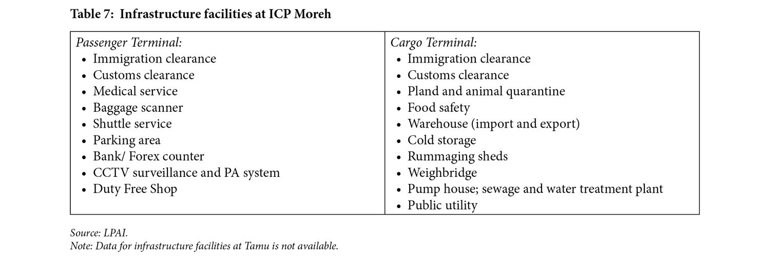
Infrastructure
Given Myanmar’s importance in connecting South Asia with South-East Asia, the infrastructure at ICP Moreh is not adequate to meet the growing need of future transactions. Although still new, there is a need to strengthen this border check-post to facilitate trade and movement of people.
Challenges
- Delay in operationalisation of the cargo terminal and land bridge: It is reported that the cargo terminal is yet to be fully operational. Due to this, the old LCS gate is still being used for trade. Additionally, a land bridge which will facilitate two way traffic is still under construction (Dutta 2019).
- Poor internet facilities: Despite an operational BSNL connection at ICP Moreh, the downtime of the internet is very high. As a result, many operations, such as customs clearance, that are digitised through the Electronic Data Interchange (EDI), are yet to function at ICP Moreh and most of the paperwork takes place physically (Export-Import Bank of India, 2018). The LPAI is seeking an additional connection for the ICP.
India-Nepal
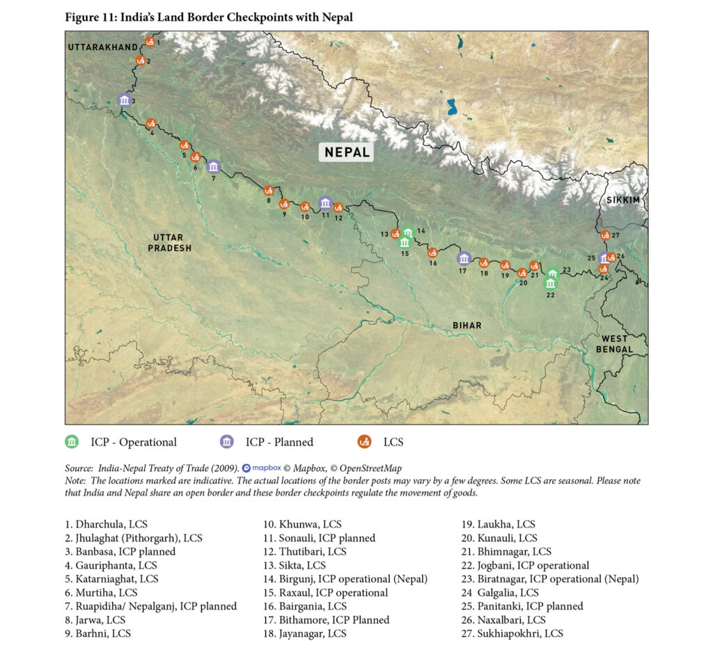
The idea of constructing four major ICPs along the India-Nepal border at Jogbani, Raxaul, Sonauli and Rupaidiha, was initially mooted in a meeting of the Committee of Secretaries in October 2003, based on a National Security Council Secretariat assessment that infrastructure at these locations was ‘abysmal’ (PSCHA, 2010, p. 14). Subsequently, in 2005, India and Nepal signed a Memorandum of Understanding (MoU) for construction of four ICPs along the 1,751 km-long shared border (Sood, 2018). In addition to developing ICPs on its side of the border, India also agreed to contribute approximately Rs 500 crore (US$ 100 million) towards the construction of mirror ICPs on the Nepali side (The World Bank, 2013).
As Nepal is a landlocked country, ICPs are integral for its commerce and security. While both countries share an open border as per the 1950 Indo-Nepal Treaty of Peace and Friendship, trade and transit take place through select border crossings identified in the Treaty of Trade (2009) and the Treaty of Transit (1999).
Currently, there are two operational ICPs at Raxaul (India)–Birgunj (Nepal) and Jogbani (India)–Biratnagar (Nepal). These two ICPs handle approximately 58% of the total trade between India and Nepal (2019–20).[16] India is also constructing a third ICP connecting Rupaidiha (India) and Nepalgunj (Nepal). The construction commenced in November 2020 (Roche, 2020a). The Treaty of Trade (2009) also identifies 24 LCS and ImCPs (Figure 11). At present only road-based transport takes place through the ICPs. Rail transfers continue to take place directly to the Inland Clearance Depot (ICD) at Birgunj. In case of the Jogbani-Biratnagar ICP, goods are transferred on a rail-cum-road basis.
India and Nepal are the only countries in South Asia to have mirror ICPs on both sides of the border. The Nepal Intermodal Transport Development Board (NITDB) is vested with the responsibility of regulating the ICPs.[17] It was established under the Development Board Act 1956, in Nepal, to manage cross-border infrastructures to facilitate Nepal’s international trade.
Terminal operations for the ICP and ICD are handed over to private companies after a competitive bidding process. The NITDB only steps in to operate these as a stop-gap arrangement when they are unable to lease out the premises to a terminal management company. Currently, ICP Birgunj is operated by the NITDB. TransNepal, a terminal company, has been operating ICP Biratnagar since August 2020.
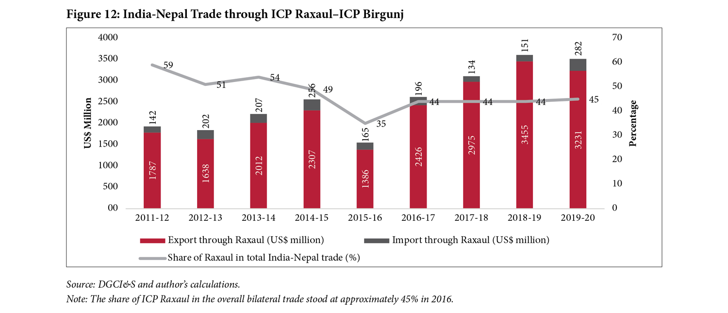
ICP Raxaul–ICP Birgunj
The ICPs at Raxaul and Birgunj were the first to be made operational between India and Nepal. The latter is the most important ICP for Nepal, catering to approximately 60% of its global trade. In 2019–20, 45% of Nepal’s total trade with India took place through this ICP (see Figure 12).[18] The foundation stone of these two mirror ICPs was laid in 2010, and the ICP at Raxaul was operationalised in June 2016. Two years later, in 2018, both Raxaul and Birgunj ICPs were jointly inaugurated. The ICP at Raxaul is located approximately 250 km from Patna in Bihar, and Birgunj ICP is located in Bara District of Nepal. The latter was constructed by an Indian public-sector unit, Rail India Technical and Economic Service Ltd (RITES), through a grant assistance of Rs 120 crore (US$ 25 million) by India (World Bank, 2013).
Trade
Since the operationalisation of ICP Raxaul in 2016, India’s exports to Nepal increased by 75% from US$ 1.39 billion in 2015–16 to US$ 2.43 billion in 2016–17. The share of ICP Raxaul in the overall bilateral trade stood at approximately 45% in 2016. The DGCI&S lists the top five commodities exported by India through this route, namely petroleum products, iron and steel, drug formulations, motor vehicles, and dairy-related industrial machinery. India imports items, such as vegetable oil, processed items, yarn and fabrics, cosmetics, and leather through the ICP.
Passenger movement
While a passenger terminal building has been built at the ICPs, minimal movement is recorded. For instance, in 2016–17, the total number of passengers crossing the border was recorded as 2,321 at Raxaul, i.e. an average of less than 10 people per day (LPAI, n.d.[f]). This is because India and Nepal maintain an open border and registered border crossings are limited to third country citizens.
Infrastructure
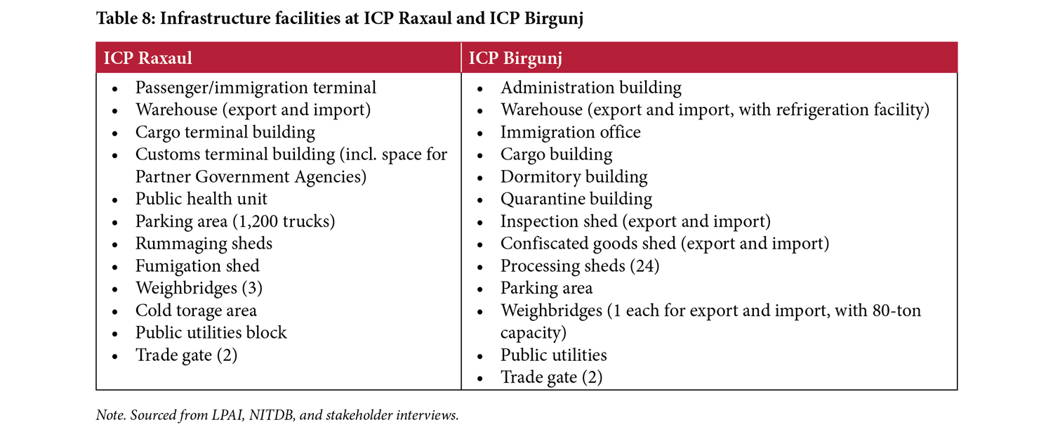
Both ICPs, Raxaul and Birgunj, are built as mirror facilities spread over 215 acres and 165 acres, respectively (NITDB, n.d.). A number of trade and non-trade-related infrastructure facilities have been provided within the ICP. Table 5 below provides a list of the infrastructure facilities available at both ICPs.
The upgrading of infrastructure at both ICPs has played a key role in reducing waiting time. Earlier it would take between two to four days from Raxaul to Birgunj, due to heavy congestion and the lack of parking areas (World Bank, 2013). Currently, the time taken to cross the border is approximately one-and-a-half days for both exports and imports.[19] On an average, 1,000 trucks cross the ICPs daily.[20]
Challenges
- The old LCS route is still operational for exports at Raxaul: Despite the inauguration of the ICPs in 2018, a complete shift to using the ICP trade gates has not taken place. Exports such as petroleum and coal continue to move from the old LCS gate due to resistance from traders (Taneja et al., 2019).
- Unpaved approach road to ICP Birgunj: The 700 m-long approach road to ICP Birgunj is rough. Road development has not taken place there for years due to land acquisition issues. The condition of the road is a major deterrent in the seamless movement of trucks and passenger vehicles.
- Inadequate warehouse space at ICP Birgunj: Stakeholder interviews reveal that the warehouse storage space at the ICP is limited and can handle only up to six containers (TEUs) at a time. Given that Nepal’s imports are higher through this route, this ICP requires more warehousing space.[21]
- Lack of digitisation at ICP Raxaul. A number of processes at ICP Raxaul take place manually, including the maintenance of records at the gates and the requirement of physical copies of entry and exit slips in triplicate. The lack of good internet connectivity in the area exacerbate this issue. As with all other ICPs, the issue can be addressed by implemenation of the the LPAI’s Land Port Management System (LPMS).
- Lack of testing facilities at the ICP: Agricultural exports from Nepal face issues due to lack of plant quarantine facilities near Raxaul. The samples are collected at Raxaul and sent to Kolkata for testing. The whole process takes about 10 days to complete, leading to accrual of detention charges on the consignment, and the rotting of some items. While the cargo volume does not justify the need for additional manpower at the ICP, there is an urgent need for developing an integrated plan for testing facilities.
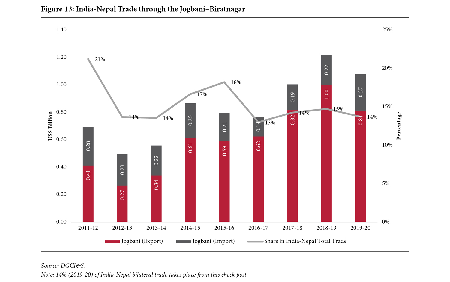
ICP Jogbani–ICP Biratnagar
The ICPs at Jogbani (India) and Biratnagar (Nepal) are the second pair of ICPs between India and Nepal. The ICP at Biratnagar was built with Indian assistance of US$19.64 million and the foundation stone for both ICPs was laid on June 26, 2010. While ICP Jogbani was completed and operationalised in 2016, there were delays in starting ICP Biratnagar. Both ICPs were jointly inaugurated on January 20, 2020.
Trade
Approximately 14% of India-Nepal bilateral trade (2019-20) is routed through ICP Jogbani. Between 2011–2020, trade figures ranged between US$ 0.5 billion to US$ 1.2 billion (Figure 13). Exports have been increasing following the operationalisation of ICP Jogbani, however the overall impact of the ICP infrastructure via-à-vis the volume of trade remains to be assessed.
Major commodities exported by India through this ICP include petroleum products, cold rolled steel sheets, non-alloy steel, liquefied petroleum gas (LPG), and milt steel billets. On the other hand, Nepal exports galvanised plain sheets and coils (GPGC), woven fabrics, galvanised iron (GI) wire, yarn, and brass sheets among other items, through this port (LPAI, n.d.[g]).
The two ICPs are also important border points for movement of transhipment cargo to Nepal from India’s eastern seaports; ICP Jogbani is located approximately 581 km from Kolkata port. Currently, the transhipment cargo moves on a rail-cum-road basis, i.e., the containers arrive by rail till Bathnaha in Bihar, from Kolkata, Haldia and Visakhapatnam ports and are then moved by road from ICP Jogbani to Biratnagar (CBIC, 2019).
In 2019, the Government of India introduced the Electronic Cargo Tracking System (ECTS) based on the Government of Nepal’s proposal for a change in modality wherein the Nepal-bound cargo can be allowed movement into Nepal without the need for the traders to file a ‘transit declaration’ with the Indian Customs. As a result, cargo movement from Indian seaports to Bathnaha by rail and then onwards to Jogbani by road could be tracked by the ECTS system (ibid.).
Passenger movement
Like ICP Raxaul and ICP Birgunj, the passenger movement through these ICPs remains low. According to available data, in 2016–17, 2,321 third-country passengers crossed this border by road (LPAI, n.d.[g]).
Infrastructure
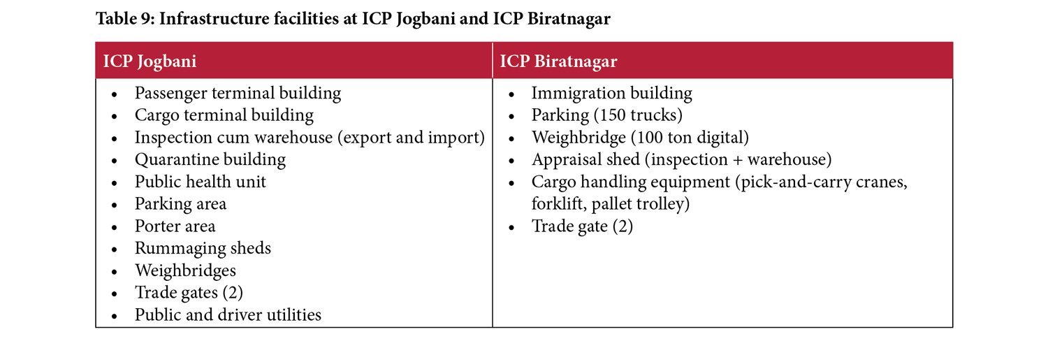
ICP Jogbani is built on an area of about 186 acres. The key infrastructure facilities at the ICP have been summarised in Table 9. Given that the ICP has been operational only for a year, it is difficult to gauge the impact of the infrastructure on the movement of goods and people. Therefore, no challenges are identified for the ICP.
Globally, the dominant mode of transport to and from neighbouring countries is land-based (via road), despite the availability of alternatives (the railways, inland waterways, and the sea). Whether it is North American trade (Mexico–USA–Canada), intra-European Union (EU) trade, or between China and Central Asia, the maximum movement of goods is via trucks and trailers (Barajas et al., 2014). An UNCTAD (2019) study also rates road as the most economical mode of transport when moving goods over shorter distances. Therefore, the emphasis on developing border infrastructure to facilitate road movement is higher. This section focuses on two case studies from the US–Mexico land border at Laredo and the Norway-Sweden land border at Svinesund to demonstrate how upgradation of border infrastructure can facilitate road-based movement of goods and people.
Laredo: Point of Entry between USA and Mexico
Approximately 80% of the trade between USA and Mexico takes place over land via trucks and railways (UNCTAD, 2019). Laredo is one of the 28 border crossings located along the 1,255 mile-long (approximately 2,020 km) border between Texas (USA) and Mexico; one of the 13 crossings that handle commercial vehicles; and one of the busiest land-based trade routes between the two countries (Texas Department of Transportation [TDT], 2019).
Laredo makes a case in point to show how improving policies and modernisation of the border-crossing infrastructure, led to decrease in time taken to cross the border and an increase in the volume of trade.
Between 2006 and 2017, the value of USA–Mexico trade increased by 68%; within this, the value of Texas–Mexico trade increased by 65%. During the same time period, the value of USA–Mexico trade moved by truck almost doubled from US$219 billion in 2006 to US$385 billion in 2017 (ibid., p. 1). Here is a brief look at the infrastructure and policy change exercises that took place during this period leading to an increase in trade volume through the Laredo Point of Entry.
Upgrading the World Trade Bridge
The World Trade Bridge in Laredo connects Texas and Mexico. Prior to its inauguration in 2000, heavy traffic congestion often led to the rerouting of trailers to other ports (ibid.). The Bridge was upgraded in 2011 and the number of lanes increased from 7 to 15 (Uribe, 2012). The Bridge now handles 40% of all incoming trucks from Mexico into Texas; in 2017 alone, it handled a total of 1.66 million trucks (TDT, 2019, p. 3). The median waiting time for trucks to cross the bridge is just one hour now (compared to five hours earlier). If the exporter and logistics company are accredited under a Customs and Border Protection ‘trusted traveller programme’, then the waiting time drops to less than 30 minutes.[22]
‘Ready Lanes’ for passengers
The Laredo point of entry has ‘Ready Lanes’ equipped with radio-frequency identification (RFID) readers for US citizens to drive through the check-posts, scan the passport card, and proceed to the Customs and Border Protection officer (U.S. Customs and Border Protection [CBP], 2018). This facilitates seamless movement of people without the need for checking of physical documents.
Unified Cargo Processing (UCP) Program
The UCP was initiated in 2017 by the US Customs and Border Protection (CBP) and its Mexican counterpart, Servicio de Administracion Tributaria (SAT). The objective was to jointly conduct inspection on cross-border trucks, thus saving time in movement (Resendiz, 2019). The authorities also share x-ray scans of trailers for joint security clearance. The UCP shipments have a dedicated lane at the border—the Free and Secure Trade (FAST) lane – that allows for unencumbered border crossing (CBP, 2018a).
Other Infrastructure upgradation
Several other facilities have been provided at the border to aid the movement of goods and people. For instance, full-body truck scanners are used on a case-by-case basis and separate gates—categorised by the level of facilitation—have been provided for seamless passenger and freight movement, as have more lanes.
Smart Borders between Norway and Sweden
The border crossings between Norway and Sweden are considered the most advanced in the world. Both countries share an approximately 1,600 km-long border, lined with about 80 crossings, only 14 of which are manned by customs officers. The busiest border crossing is at Svinesund with approximately 66,000 monthly freight-truck movements (Karlsson, 2017, p. 28). The border houses the most developed customs solution in the world, using all the international standard of the World Customs Organisation and full compliance with the World Trade Organisation’s Trade Facilitation Agreement. Most goods traffic is cleared at an average time of 3-9 minutes post arrival at the border (ibid. pp. 29-30).
While Sweden is one of the 27 EU member states, and thus, a de facto signatory to all EU agreements, Norway is a member of the European Economic Area and the Schengen Agreement, but not the EU Customs Union. As a result, customs controls are required for the border between Norway and Sweden. In 1997, an agreement on customs cooperation between the European community and the Kingdom of Norway was signed, allowing Sweden and Norway to coordinate for joint customs administration. The smart border between Norway and Sweden is a case in point that highlights how technology can support seamless cross-border movements. Such technology upgradations need to be supported with infrastructure and political will to facilitate cross-border flows. There are several good practices operational at this border, especially since the inauguration of the Svinesund bridge in 2005, that can be mirrored or adapted globally.
Large area of border check-posts
Despite having a considerably smaller volume of freight traffic as compared to South Asian countries, Norway and Sweden have a 15 km-long border control zone on either side of the border, to regulate freight and passenger traffic.
Joint customs control within the border control zone
Either of the customs authorities of Norway and Sweden can carry out the customs formalities within the control zone. The systems of both countries are digitally linked allowing for real-time information sharing between both countries (ibid., p. 28).
Automatic number-plate recognition (ANPR)
Since 2011, Norway has been using the ANPR cameras at border crossings without customs posts to scan the number plates of the trucks and passenger cars, and check for uninsured vehicles, traffic violations, and illegal entry (Cellan-Jones, 2017). This technology, however, is yet to be integrated with the customs system.
Full body x-ray scanners
Approximately four full-body truck/lorry x-ray scanners have been installed in the border control zone, which scan every crossing truck for contraband, illegal food, and agricultural products(ibid.).
In 2020, the Home Minister of India announced that many LCSs in the Northeast region would be upgraded to ICPs (IANS, 2020). Additionally, the LPAI envisages the operationalisation of 24 ICPs by 2030. This infrastructure development along India’s land borders begs two key questions: (i) are ICPs really facilitating freight and passenger movement between India and its neighbours?; and (ii) with various regional connectivity infrastructure projects in the pipeline, what role will the ICPs play?
As part of India’s ‘Act East’ and ‘Neighbourhood First’ policies, several regional connectivity initiatives have been taken in South Asia that warrant a reassessment of the role that ICPs would play in trade facilitation and movement of people.
First, an empirical analysis of the various operational ICPs in the region shows an increase in trade and movement of people post the operationalisation of the ICPs. For instance, India’s exports to Nepal increased by 75% post initiation of ICP Raxaul in 2016; the share of ICP Attari in India’s total trade with Pakistan increased from 17% in 2011–12 to 33% in 2013–14, signifying re-routing of trade from sea; and the passenger movement through ICP Moreh increased by approximately 530% in 2018–19.
Most of the current operational ICPs, including Raxaul and Petrapole, are operating at over 100% capacity. Any further increase in volume leads to congestion on the approach roads and within the ICPs. The volume of freight and passenger traffic is soon likely to increase with various connectivity infrastructure initiatives linked to the ICPs coming to fruition. Therefore, it is important that a pre-emptive growth estimation be done for traffic through the ICPs, so that adequate facilities can be provided for different types of cargo while maintaining the export clearance time as 24 hours, based on the National Trade Facilitation Action Plan 2020–23 (NCTF, 2020).
Secondly, as part of India’s ‘Act East’ and ‘Neighbourhood First’ policies, several regional connectivity initiatives have been taken in South Asia that warrant a reassessment of the role that ICPs would play in trade facilitation and movement of people. These regional connectivity initiatives, particularly the Bangladesh-Bhutan-India-Nepal Motor Vehicles Agreement (BBIN-MVA), development of cross-border railways, and inland waterways transport, will increase the mandate of the ICPs. Table 10 below provides a list of key infrastructure projects between India and the neighbouring countries.
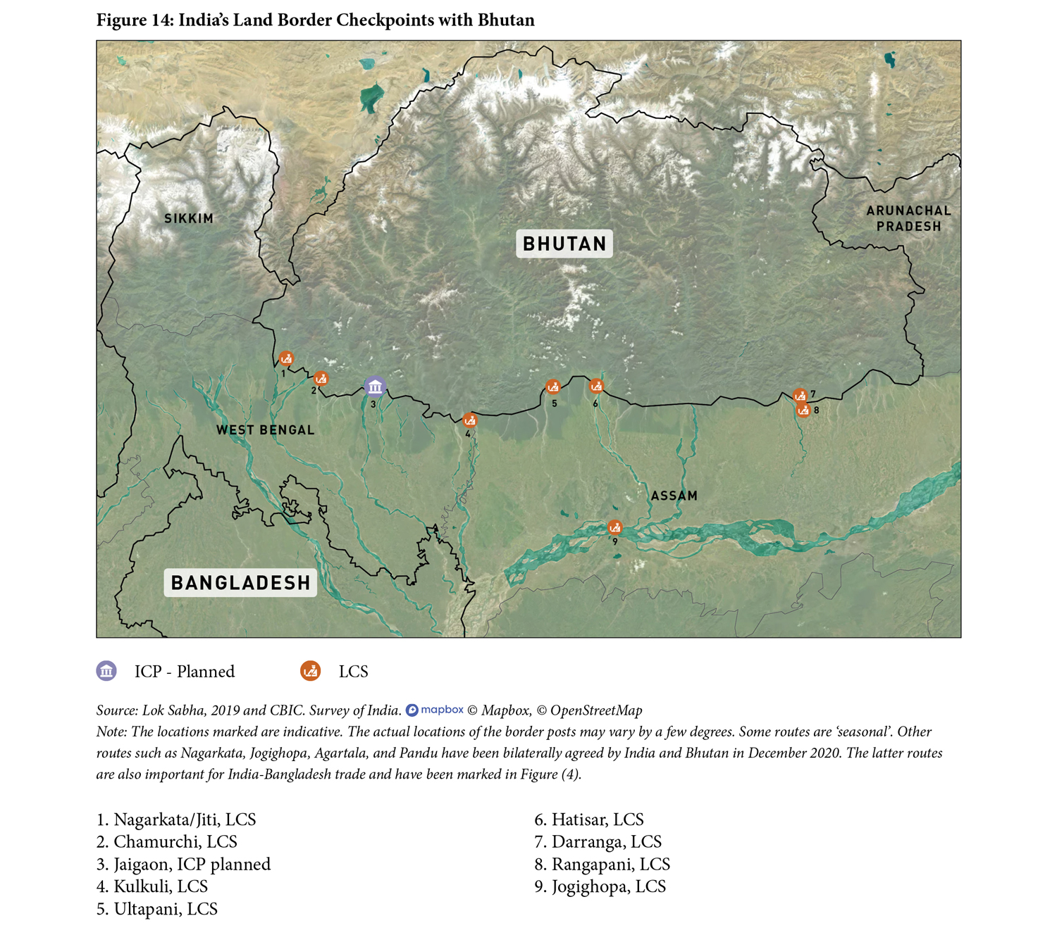
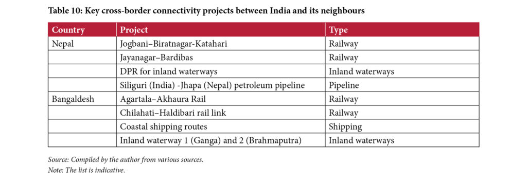 With Nepal, rail connectivity projects such as the Jogbani–Biratnagar and the Jayanagar–Bijalpura–Bardibas railway link are nearing completion (Indo-Nepal Railway Project, 2021). Apart from this, India has also offered assistance in developing inland waterway transport with Nepal. With Bhutan, India inaugrated a new route between Jaigaon (West Bengal) and Ahllay, Pasakha (Bhutan) to decongest vehicluar traffic along Jaigaon-Phuentsholing route (Figure 14). In 2020, India opened four more trade routes with Bhutan at Nagarkata, Agartala, Jogighopa, and Pandu. The latter two are riverrine ports.
With Bangladesh, four rail lines are now operational. The 12 km-long Agartala–Akhaura railway link is under execution; this route is expected to cut travel time between Tripura and Kolkata via Dhaka and facilitate freight movement from India’s Northeastern states to Kolkata. Inland waterways is another mode that has seen development in recent years. In September 2020, during the pilot test of the Chittagong–Tripura inland waterway route, 50 MT of cement was transported on river Gomti from Daudkandi (Bangladesh) to Sonamura (India) via a 90 km waterway (Deb, 2020).
With such an increase in the regional connectivity initiatives, it is important to delve into the future role of ICPs and ascertain the infrastructure facilities required for the same. It is likely that there will be an increasing focus on off-border clearances, that is, customs clearance taking place at an inland customs location rather than when cargo reaches the ICP.
According to a former MEA official, the planning for key projects such as roads and ICPs is done on a ‘past-experience’ basis and not a ‘forward-looking’ approach. For instance, he notes that roads are built based on the current traffic volume and not on future projections; and consultants and planners work on old statistics. Given the huge potential of these routes in facilitating multi-modal transportation, it is important that infrastructure be developed at the ICPs keeping future potential in mind, and not on existing trade and transit figures. There is also a need to ensure alignment of the existing border infrastructure, including the ICPs, with the above-mentioned regional connectivity initiatives to accrue maximum benefit for trade facilitation and to ensure the seamless movement of people across sub-regions. Such developments warrant infrastructure upgradation and investment in technology upgradation in the border areas.
Furthermore, at an inter-regional level, ICPs are envisaged to connect the transport of Indian goods to the Northeast region transiting via Bangladesh, and further link them with supply chains in South-East Asia. Several other connectivity initiatives are also at various stages of development connecting South Asia with South-east Asia, such as the India—Myanmar—Thailand (IMT) Trilateral Highway, Asian Highways 1 and 2, the Trans-Asian railway network, among others. Some of these routes intersect at the ICPs. For instance, the IMT route passes through ICP Moreh. The infrastructure is expected to play a key role in multi-modal transportation in the region and pave way for easing transportation from South Asia to South-East Asia. For instance,
While the need for ICPs arose out of border security concerns, increasing the volume of trade with neighbouring countries as well as connectivity through important infrastructure projects should be the driving factor behind selection of the LCS’ for upgradation to ICPs. The construction of ICPs has shown significant improvements at certain places, however, not much improvement has taken place at other border points due to lack of a mirror infrastructure in the neighbouring countries. For instance, the case of ICP Petrapole shows that the increase in freight traffic has been limited due various infrastructural deficits, such as the lack of adequate parking and warehousing space at the corresponding land port in Benapole, Bangladesh.
Apart from this, several common challenges exist across the ICPs, including harmonisation of working hours with neighbouring countries, limitations in truck movement, absence of partner government agencies such as plant and animal quarantine, and paucity of warehousing space. These challenges will need to be addressed for further construction of the ICPs, in order to promote seamless regional trade and logistics.
In total, 40% of the land-based goods trade between India and its neighbours takes place via the Integrated Check Posts (ICPs). The idea of establishing ICPs along India’s border with its neighbouring countries was mooted by the KRC Report in 2000. This led to several developments on the administrative front—from forming a Department of Border Management in the Ministry of Home Affairs in 2003, to constituting an autonomous body called LPAI for management of the ICPs in 2010. The first ICP was inaugurated in 2012 at the Attari border between India and Pakistan. Subsequently, ICPs were also established at Agartala (Tripura), Raxaul (Bihar), Petrapole (West Bengal), Moreh (Manipur), Jogbani (Bihar) and Katarpur (Punjab).
In total, 40% of the land-based goods trade between India and its neighbours takes place via the Integrated Check Posts.
As global best practices at the USA–Mexico and Norway–Sweden border check posts show, technologies and policy practices that reduce time and cost of trade already exist globally. Their implementation is dependent on cooperation and the political will of countries. The Covid-19 crisis has particularly alerted countries on the importance of smart border control technologies to enable contact-free transfer of goods and people across borders. This is an opportune moment to re-evaluate the approach towards development of border infrastructure and re-align it, taking cognizance of the trade potential and the capacity to handle ‘unforeseen emergencies.’
The ICPs are an ambitious model for improving border management infrastructure. The nine operational ICPs in India and two in Nepal since 2012, show the capacity of the Government of India to deliver on the project and are a testament to the rising demand from India’s smaller neighbours. Therefore, it is important to leverage India’s strength and success story in this area for achieving greater regional integration. It is also important that the next ICPs should be developed based on need, trade potential and their future role among other regional connectivity initiatives in South Asia.
At the inter-governmental level
- Development of ICPs in line with other regional infrastructure connectivity initiatives
All ICPs should be developed to complement the other regional infrastructure connectivity initiatives. For instance, the construction of an ICP at Sabroom in Tripura, was announced to complement the recently inaugurated ‘Friendship Bridge’ between India and Bangladesh over River Feni in Sabroom. Similarly, infrastructure (including ICDs) that exists at the border in neighbouring countries can be linked with ICPs. The LPAI and other stakeholders in the Government of India must take cognizance of existing and planned infrastructure projects at the border areas during project planning.
2. Upgrading infrastructure at the ICPs, and technological cooperation with neighbouring countries
There is a need to develop mirror ICP infrastructure with the requisite facilities in Bangladesh (Akhaura and Benapole), and Myanmar (Tamu) to ensure seamless clearance of goods, and the creation of a real-time data exchange platform between the customs authorities, immigration, custodians, and security personnel of both countries to ensure paperless and no-contact transactions. As in the case of Nepal (Birgunj and Biratnagar), India can commission the construction of ICP infrastructure in the neighbouring countries through MEA grants. For Benapole (Bangladesh), this request was also made by traders during the 4th Meeting of the Council for Trade Development and Promotion held on January 10, 2019 (MoCI, 2019). Additionally, through its own experience, India can support Nepal, Bangladesh and Myanmar in capacity building for implementation of the TIR Carnets.
3. Development of ICDs where ICPs cannot be expanded
While the border between Norway and Sweden boasts of a 15 km-long border control zone, such zones are difficult to build in South Asia due to paucity of land, land acquisition issues and the lack of a joint policy between any two countries on border movement in the region. The LPAI and the Ministry of Commerce and Industry can explore establishing ICDs as an extension of the ICPs for customs clearance, and increasing the parking and warehouse space.
4. Explore the possibility of management and operations of the ICPs on a PPP model
The MHA mooted a public-private partnership model for ICPs in the late 2000s, which was struck down citing security reasons. However, times have changed. It is expected that growth in regional connectivity initiatives such as railways, inland waterways, bridges and ICPs, will generate a higher volume of cargo flow through the region. According to a former MEA official, the security and commercial approach must go hand in hand when it comes to these ICPs. Therefore, the LPAI can explore the possibility of management and operations of the ICPs on a PPP model in order to enhance efficiencies, address capacity issues and reduce logistics cost.
At the ground-level
- Need for PGA/testing facilities
A common challenge across all ICPs is lack of representation from Partner Government Agencies, such as plant and animal quarantine, drug control, etc. While it is not feasible to have manpower from these agencies at every land port due to the volume of trade, an alternative nevertheless needs to be developed by the LPAI and CBIC to address this issue. A possible option would be to create an integrated system of accredited labs within a 12-hour distance of the ICP, using courier services for movement of samples.
- Improving infrastructure of the approach roads and bridges
There is a need to upgrade the condition of approach roads leading to all ICPs in the region. This will lower the cost of transportation and reduce road-traffic congestion. This can be accomplished by the efforts of the MHA, the Ministry of Road Transport and Highways and the relevant state governments working together. The National Highways and Infrastructure Development Corporation Ltd, which is playing a key role in upgrading the India–Myanmar bridge at Moreh, will have to expedite completion to enable higher volumes of freight movement.
- Timely implementation of the Land Port Management System
Adequate internet facilities need to be provided in all the border areas for the digitisation process to be fully implemented at all ICPs. Paperless transactions will generate time and cost savings, whilst facilitating proper recording of information related to trade and passenger movement. The Land Port Management System needs to be implemented urgently in order to integrate various stakeholders and the documentation process at the ICPs.
- Focus on off-border customs facilitation
Off-border facilitation and clearances—similar to the procedure taking place at the seaports—could be considered, given the paucity of parking and warehousing space at the ICPs. Off-border facilitation could possibly take place at an inland dry port, and, for instance, only trucks with a ‘Let Export Order’, would be allowed to enter ICP premises. Such measures will not only reduce congestion at the ICP but will also address the issue of intermittent internet connectivity which is, at present, necessitating paper-based transactions.
- Enabling provisional clearance of cargo by customs
The CBIC has provided the facility of provisional clearance of cargo at seaports—allowing the importer to take the cargo from port, based on a bond. This provision will also be useful for land ports, particularly in the case of perishable goods that face warehousing and cold storage issues.
- Creation of Facilitation Lanes at the ICP
In order to expedite movement of cargo and passenger vehicles, facilitation lanes can be created at ICP gates on the model of the USA-Mexico border (discussed in previous section). The facilitation can be based on several predetermined parameters, such as RFID tags and cargo with a Let-export-order. This would enable faster movement of goods and passenger vehicles for authorised operators and passengers, significantly reducing the dwell time of vehicles at the ICP.
Ali, S.S. (2021, January 14). Centre releases Rs 90.56 crore for second Integrated Check Post in Tripura. The Hindu. Retrieved January 15, 2021, from https://www.thehindu.com/news/national/other-states/centre-releases-9056-crore-for-second-integrated-check-post-in-tripura/article33576385.ece
Bangladesh Land Port Authority. (n.d.). Overview. Retrieved from http://bsbk.portal.gov.bd/sites/default/files/files/bsbk.portal.gov.bd/page/1da6d5ad_5287_4dc7_8146_0326260b1894/overview%20(Sep%2716).pdf
Barajas, I.A., Sisto, N.P., Gaytán, E.A., Cantú, J.C., and López, H.L. (2014, October 10). Trade flows between the United States and Mexico: NAFTA and the border region. Articulo – Journal of Urban Research [Online]. DOI: https://doi.org/10.4000/articulo.2567
Bassi, A. (2017, May 12). Attari check post gets modern surveillance equipment. Hindustan Times. Retrieved October 22, 2020, from https://www.hindustantimes.com/punjab/attari-post-gets-modern-surveillance-equipment/story-9u94ixb4IoPfh2OJCleg6H.html.
Bose, P.R. (2018, November 12). At Moreh, trade with Myanmar borders on informal. The Hindu Business Line. Retrieved October 30, 2020., from https://www.thehindubusinessline.com/news/at-moreh-trade-with-myanmar-borders-on-informal/article25478894.ece
Bureau of Immigration. (n.d.). About Us. Retrieved August 4, 2020, from https://boi.gov.in/
Cellan-Jones, R. (2017, September 29). Frictionless borders: learning from Norway. BBC. Retrieved from https://www.bbc.com/news/technology-41412561
Central Board of Indirect Taxes and Customs. (1962). The Customs Act, 1962. Retrieved from https://www.cbic.gov.in/htdocs-cbec/customs/cs-acts-botm
Central Board of Indirect Taxes and Customs. (2019, September 29). Transhipment of Cargo to Nepal under Electronic Cargo Tracking System Regulations, 2019. (Notification No. 68/2019-Customs (N.T.)). Retrieved from https://www.cbic.gov.in/resources/htdocs-cbec/customs/cs-act/formatted-htmls/Cargo-Tracking-System-English.pdf
CUTS. (2019). India–Bangladesh agriculture trade: Demystifying non-tariff barriers to India–Bangladesh trade in agricultural products and their linkages with food security and livelihood. Jaipur, India: CUTS International. Retrieved from https://cuts-citee.org/pdf/project_report-ntbagr.pdf
CUTS. (2015), Trade facilitation, trade costs and inclusive development: A case story of Attari-Wagah border of India and Pakistan. Retrieved from http://www.cuts-citee.org/pdf/CUTS_Case_Story_on_Trade_Faciltiation.pdf
Das, P. (2021, February 7). Border Management and Threats to Internal Security. Electronic Journal of Social Sciences and Strategic Studies, 2(1), 89–110. Retrieved from https://www.ejsss.net.in/article_html.php?did=9311&issueno=0
De, P., and Iyengar, K. (Eds). (2014). Developing economic corridors in South Asia. Mandaluyong City, Philippines: Asian Development Bank. Retrieved from https://www.adb.org/sites/default/files/publication/162073/developing-economic-corridors.pdf
Deb, D. (2020, September 7). Explained: What the opening of waterway with Bangladesh means for Tripura. The Indian Express. Retrieved from https://indianexpress.com/article/explained/explained-what-the-opening-of-waterway-with-bangladesh-means-for-tripura-6584061/
Department-Related Parliamentary Standing Committee on Home Affairs (2010). One Hundred and Forty Third Report On The Land Ports Authority Of India Bill, 2009. Rajya Sabha Secretariat, Government of India. Retrieved from https://prsindia.org/files/bills_acts/bills_parliament/SCR_Land_Ports_Authority_of_India_Bill,_2009.pdf
Doval, N. (2020, March 6). India-Pakistan Trade: Border Trauma. Open Magazine. Retrieved January 16, 2021, from https://openthemagazine.com/features/dispatch/india-pakistan-trade-border-trauma/
Dutta, S. (2019, June 26). Moreh–Tamu: an unfulfilled potential. Vivekanada International Foundation. Retrieved from https://www.vifindia.org/article/2019/june/26/moreh-tamu-an-unfulfilled-potential
Export-Import Bank of India. (2018). Act East: Enhancing India’s trade with Bangladesh and Myanmar across border. (Working Paper no. 77). New Delhi: Export-Import Bank of India. Retrieved from https://www.eximbankindia.in/Assets/Dynamic/PDF/Publication-Resources/ResearchPapers/97file.pdf
Godbole, M. (2014, December 03). Lecture by Dr Madhav Godbole on “Securing India’s Borders—The Way Ahead” [Speech]. Manohar Parrikar Institute for Defence Studies and Analyses. Retrieved from https://idsa.in/keyspeeches/LecturebyDrMadhavGodbole
Group of Ministers (n.d.). Report on National Security. Vivekananda International Foundation. Retrieved September 10, 2020, from https://www.vifindia.org/sites/default/files/GoM%20Report%20on%20National%20Security.pdf
Gupta, A. K. (2018). Strengthening Transport Connectivity in Southern and Central Asia [PowerPoint slides]. South and South-West Asia Office, UNESCAP. https://www.unescap.org/sites/default/files/Anil_Gupta7_8feb2018.pdf
Indo-Nepal Railway Project: India Govt spend 500 cr to improve connectivity. (2021, January 18). LiveMint. Retrieved from https://www.livemint.com/news/india/indonepal-railway-project-india-govt-spend-rs-500-cr-to-improve-connectivity-11610932818082.html
Ministry of Commerce and Industry. (2012). Joint Statement of the 7th Round of Talks on Commercial and Economic Co-Operation Between Commerce Secretaries of India And Pakistan. (2012, September 21). Retrieved from http://commerce.nic.in/trade/Joint_Press_Statement_CS_Pakistan_India_Sept_20_21st_2012.pdf
Karlsson, L . (2017). Smart Border 2.0: Avoiding a hard border on the island of Ireland for Customs control and the free movement of persons. Policy Department for Citizens’ Rights and Constitutional Affairs, Directorate General for Internal Policies of the Union, European Parliament. Retrieved from http://publications.europa.eu/resource/cellar/a9c80272-fcca-11e7-b8f5-01aa75ed71a1.0001.03/DOC_1
Kathuria, S. (Ed). (2018). A Glass Half Full: The Promise of Regional Trade in South Asia. Washington, DC: The World Bank. Retrieved from https://openknowledge.worldbank.org/handle/10986/30246
Land Ports Authority of India. (n.d.[a]). Genesis. Retrieved September 20, 2020, from http://www.lpai.gov.in/content/innerpage/genesis.php
Land Ports Authority of India. (n.d.[b]). Facilities. Retrieved September 20, 2020, from http://www.lpai.gov.in/content/innerpage/facilities.php
Land Ports Authority of India. (n.d.[c]). ICP Attari. Retrieved October 25, 2020, from http://lpai.gov.in/content/innerpage/icp-attari.php
Land Ports Authority of India. (n.d.[d]). ICP Agartala. Retrieved October 18, 2020, from http://lpai.gov.in/content/innerpage/icp-agartala.php
Land Ports Authority of India. (n.d.[e]). ICP Petrapole. Retrieved October 18, 2020, from http://lpai.gov.in/content/innerpage/icp-petrapole.php
Land Ports Authority of India. (n.d.[f]). Raxaul–Birgunj. Retrieved October 22, 2020, from http://lpai.gov.in/content/innerpage/icp-raxaul.php
Land Ports Authority of India. (n.d.[g]). ICP Jogbani. Retrieved October 22, 2020, from http://lpai.gov.in/content/innerpage/icp-jogbani.php
Land Ports Authority of India. (n.d.[h]). ICP Moreh. Retrieved October 26, 2020, from http://lpai.gov.in/content/innerpage/icp-moreh.php
Land Ports Authority of India. (n.d.[i]). Roadmap of ICPs. Retrieved September 20, 2020, from http://lpai.gov.in/content/innerpage/next-phase.php
Land Ports Authority of India. (2019). 7th Annual Report 2018–19. Retrieved from http://lpai.gov.in/upload/uploadfiles/files/Annual%20Report%202018-19.pdf
Mehudia, S. (2012, April 14). Attari border will become a trade hub. The Hindu. Retrieved October 20, 2020, from https://www.thehindu.com/business/attari-border-will-become-a-trade-hub/article3314985.ece
Ministry of Commerce. (n.d.). [Table:] Export/import border trade situation of Myanmar in 2012–2013 Fical Year To 2019–2020 Fiscal (up to February monthly). Republic of the Union of Myanmar. Retrieved from https://www.commerce.gov.mm/en/article/export-import-border-trade-situation-myanmar-2012-2013-fical-year-2019-2020-fical-year?__cf_chl_jschl_tk__=c9061009fc839e1e07b9139820b9eeeedde180ca-1617084441-0-AeUtjwmCYtZWUp_hpEegL6qBcQAlniMPUIVR4mD3YxB4B4MTk8sCL8U
Ministry of Commerce and Industry (2019). 4th Meeting of Council for Trade Development and Promotion held on 10 January 2019. Retrieved from https://commerce.gov.in/wp-content/uploads/2020/07/MOC_636882650768706682_ROD_4th_Council_for_Trade_Development_and_Promotion.pdf
Ministry of External Affairs. (2015, June 6). Trade Agreement between India and Bangladesh. MHA, Government of India. Retrieved from http://www.mea.gov.in/Portal/LegalTreatiesDoc/BG15B2412.pdf
Ministry of External Affairs. (2016, July 21). Joint dedication of the Petrapole Integrated Check Post (ICP) [Press release]. Retrieved from https://mea.gov.in/press-releases.htm?dtl/27118/Joint_dedication_of_the_Petrapole_Integrated_Check_Post_ICP
Ministry of External Affairs. (2019, September 18). Transcript of Press Conference by External Affairs Minister on 100 days of Government (September 17, 2019) [Press release]. Retrieved from https://www.mea.gov.in/media-briefings.htm?dtl/31833/Transcript+of+Press+Conference+by+External+Affairs+Minister+on+100+days+of+Government+September+17+2019
Ministry of External Affairs. (2021, February 15). Lecture by External Affairs Minister on Act East Policy and India-Japan cooperation in North East India with a special focus on Assam [Speech]. Retrieved from https://www.mea.gov.in/Speeches-Statements.htm?dtl/33523/Lecture_by_External_Affairs_Minister_on_Act_East_Policy_and_IndiaJapan_cooperation_in_North_East_India_with_a_special_focus_on_Assam
Ministry of Health and Family Welfare. (2020, March 14). Restriction of international passenger traffic through Land Check Posts in view of the spread of Covid-19 (Office Memorandum no. 25022/12/2017-lmm). Retrieved from https://www.mohfw.gov.in/pdf/NewinstructionsDt14032020Restirctiononinternationalpassengertraffic.pdf
Ministry of Home Affairs. (2004). Annual Report 2003–04. Retrieved from https://www.mha.gov.in/documents/annual-reports
Ministry of Home Affairs. (2008). Annual Report 2007–08. Retrieved from https://www.mha.gov.in/documents/annual-reports
Ministry of Home Affairs. (2009). Annual Report 2008–09. Retrieved from https://www.mha.gov.in/documents/annual-reports
Ministry of Home Affairs. (2011). Annual Report 2010–11. Retrieved from https://www.mha.gov.in/documents/annual-reports
Ministry of Home Affairs. (2012). Annual Report 2011–12. Retrieved from https://www.mha.gov.in/documents/annual-reports
Ministry of Home Affairs. (2013). Annual Report 2012–13. Retrieved from https://www.mha.gov.in/documents/annual-reports
National Committee on Trade Facilitation. (2020). Implementation of the Trade Facilitation Agreement: National Trade Facilitation Action Plan 2020–23. Retrieved from https://www.cbic.gov.in/resources//htdocs-cbec/implmntin-trade-facilitation/NTFAP2020-23jk.pdf;jsessionid=47DB608F30BBA17D412EE05FBEB949D7
National Transport Development Policy Committee. (2014). ‘Promoting International Transport Connectivity Between India And the South and South East Asia Regions’. In India Transport Report: Moving India to 2032 (p. 593). New Delhi: Routledge. Retrieved from http://niti.gov.in/planningcommission.gov.in/docs/reports/genrep/NTDPC_Vol_02.pdf
Nepal Intermodal Transport Development Board. (n.d.). Birgunj ICP. Retrieved from http://nitdb.gov.np/wp-content/uploads/2018/05/Details-of-Birgunj-ICP.pdf
Noyon, A.U. (2020, July 5). Bangladesh India trade relations under strain. The Business Standard. Retrieved September 10, 2020, from https://tbsnews.net/economy/trade/bangladesh-india-trade-relations-under-strain-102277
Pandher, S. (2012, April 11). Attari Integrated Check Post to open for trade on Friday. The Hindu. Retrieved September 24, 2020, from https://www.thehindu.com/news/national/attari-integrated-check-post-to-open-for-trade-on-friday/article3304431.ece
Petrapole-Benapole ICP to be run 24 hours (2017, August 1). The Hindu. Retrieved October 20, 2020, from https://www.thehindu.com/business/Economy/petrapole-benapole-icp-to-be-run-24-hours/article19401527.ece
Press Information Bureau. (2017, March 6). Cabinet approves India’s accession to the Customs Convention on International Transport of Goods under cover of TIR Carnets (TIR Convention) [Press Release]. Retrieved from https://pib.gov.in/PressReleseDetail.aspx?PRID=1483815
Press Information Bureau. (2020, July 16). Union Shipping Minister flags off first container ship from Kolkata Port to Agartala via Chattogram port [Press Release]. Retrieved from https://pib.gov.in/Pressreleaseshare.aspx?PRID=1639055#:~:text=Union%20Shipping%20Minister%20flags%20off,to%20Agartala%20via%20Chattogram%20port&text=Union%20Minister%20of%20State%20for,Bangladesh%2C%20in%20a%20virtual%20ceremony.
Raja, S. (2020, August 13). Storage space fills up with overdue import at Benapole port. Dhaka Tribune. Retrieved October 20, 2020, from https://www.dhakatribune.com/bangladesh/nation/2020/08/13/storage-space-fills-up-with-overdue-import-at-benapole-port
Raja, S. (2020, October 16a). Indian truck parking syndicates impede imports at Benapole. Dhaka Tribune. Retrieved October 20, 2020, from https://www.dhakatribune.com/bangladesh/nation/2020/10/16/indian-truck-parking-syndicates-impede-imports-at-benapole
Resendiz, J. (2019, September 30). CBP, Mexico takes steps to speed up border trade at Laredo ports of entry. Border Report. Retrieved December 4, 2020, from https://www.borderreport.com/border-report-tour/cbp-mexico-take-steps-to-speed-up-border-trade-at-laredo/
Reuters. (2017, June 16). Nepal’s colonial-era rail link slowly chugs back to life. The Wire. Retrieved October 3, 2020, from https://thewire.in/external-affairs/nepal-colonial-era-rail-link
Roche, E. (2020, August 17). India, Nepal need to speed up implementation of projects in the Himalayan region. LiveMint. Retrieved September 20, 2020, from https://www.livemint.com/news/india/india-nepal-to-speed-up-implementation-of-projects-in-himalayan-nation-11597669632498.html
Roche, E. (2020, November 13a). India, Nepal Launch Construction of Third Integrated Check Post. LiveMint. Retrieved January 21, 2020, from https://www.livemint.com/news/india/india-nepal-launch-construction-of-third-integrated-check-post-11605277418383.html
Samom, S. (2018, August 9). India–Myanmar border land road formally opened. Hindustan Times. Retrieved from https://www.hindustantimes.com/india-news/new-friendship-bridge-that-connects-india-with-myanmar-opens/story-VFkwUpth7wV9uq5KidfotI.html
Sanyal, S. (2018, March 12). Integrated check post near Agartala to be commissioned shortly. The Hindu Business Line. Retrieved from https://www.thehindubusinessline.com/economy/logistics/integrated-check-post-near-agartala-to-be-commissioned-shortly/article23104445.ece
Sinha, R., & Sareen, N. (2020). India’s limited trade connectivity with South Asia. New Delhi: Brookings Institution India Centre. Retrieved from https://www.brookings.edu/wp-content/uploads/2020/05/Trade-Policy-Brief.pdf
Sinha, R. & Sharma, B. (2020). Travel South Asia: India’s Tourism Connectivity with the Region. New Delhi: Brookings Institution India Centre. Retrieved from https://www.brookings.edu/research/travel-south-asia-indias-tourism-connectivity-with-the-region/
Sinha, S., Hussain, A., Sinha, R., Chakraborty, S., & Malik, A. (2016). Bridging Infrastructural Deficits at Select Trade Ports in India. New Delhi, India: Bureau of Research on Industry and Economic Fundamentals. Retrieved from https://www.briefindia.com/wp-content/uploads/2017/05/Bridging-Infrastructural-Deficits.pdf
Sood, R. (2018, April 11). A new beginning with Nepal. The Hindu. Retrieved December 4, 2020, from https://www.thehindu.com/opinion/lead/a-new-beginning-with-nepal/article23496223.ece
Suneja, K. (2019, February 17). India hikes customs duty to 200 per cent on all goods imported from Pakistan. Economic Times. Retrieved October 26, 2020, from https://economictimes.indiatimes.com/news/economy/policy/india-hikes-customs-duty-to-200-pc-on-all-goods-imported-from-pakistan/articleshow/68026919.cms?utm_source=contentofinterest&utm_medium=text&utm_campaign=cppst
Taneja, N., Prakash, S., Bimal, S., Garg, S., & Roy, R. (2019). Strengthening India-Nepal economic relations. New Delhi: Indian Council for Research on International Economic Relations. Retrieved from http://icrier.org/pdf/Working_Paper_381.pdf
Texas Department of Transportation. (2019, January). Texas border district trade transportation activities. Retrieved from https://ftp.txdot.gov/pub/txdot/move-texas-freight/studies/border-activities-report.pdf
The World Bank. (2013). Project Appraisal Document: South Asia: Nepal India regional trade and transport project. Retrieved from http://documents1.worldbank.org/curated/pt/801711468306290657/pdf/781990PAD0P144010Box377322B00OUO090.pdf
Tripura Tourism Development Corporation Limited (TTDCL). (2020, January 20). Short notice quotation for selection of vendor for construction of tourist information centre at arrival lounge of Integrated Check Post at Akhaura, Agartala during the year 2019–20. Retrieved from https://tripura.gov.in/sites/default/files/20200120-Construction-TIC-AkhauraICP.pdf
United Nations Conference on Trade and Development. (2019). The Time Cost Distance Model. [PowerPoint Slides]. UNCTAD. https://unctad.org/system/files/non-official-document/aldc2019_ethiopia_servicestrade_Valentine3_UNCTAD_en.pdf
Uribe, M.O. (2012, October 29). NAFTA’s promise slowed by lack of border infrastructure. Marketplace. Market Place. Retrieved from https://www.marketplace.org/2012/10/29/naftas-promise-slowed-lack-border-infrastructure/
U.S. Customs and Border Protection. (2018, October 5). CBP to Launch Awareness Campaign for Ready Lane at South Texas Ports of Entry. Retrieved from https://www.cbp.gov/newsroom/local-media-release/cbp-launch-awareness-campaign-ready-lane-south-texas-ports-entry
US Customs and Border Protection. (2018, September 28a). U.S. CBP and Mexico SAT announce Unified Cargo Processing at the El Paso port of entry. Retrieved from https://www.cbp.gov/newsroom/local-media-release/us-cbp-and-mexico-sat-announce-unified-cargo-processing-el-paso-port
US Customs and Border Protection. (n.d.). Securing and Facilitating Trade in North America. UCBP, US Department of Homeland Security. Retrieved from https://www.cbp.gov/border-security/ports-entry/cargo-security/c-tpat-customs-trade-partnership-against-terrorism/mutual-recognition/aeo-programs/
Xavier, C. (2020). Sambandh as strategy: India’s new approach to regional connectivity. New Delhi, India: Brookings Institution India Centre. Retrieved from https://www.brookings.edu/wp-content/uploads/2020/01/India%E2%80%99s-New-Approach-to-Regional-Connectivity-V3_M.pdf
Xavier, C., & Sinha, R. (2020). ‘Regional Connectivity and India’s BIMSTEC Policy’. National Security, III(1), 34–51. Retrieved from https://www.vifindia.org/sites/default/files/national-security-vol-3-issue-1-article-CXRS.pdf
FOOTNOTES
1] Other border-trade centres include border haats, trade facilitation centres for barter trade etc.
[2] Calculated by author with data from Directorate General of Commercial Intelligence and Statistics (DGCI&S), Ministry of Commerce and Industry, Government of India.http://www.dgciskol.gov.in/.
[3] Ibid.
[4] In the aftermath of the Kargil War, the then Prime Minister, Atal Bihari Vajpayee, set up a Kargil Review Committee (KRC). He also subsequently set up a Group of Ministers to examine the KRC report and suggest measures to enhance border security.
[5] Data from Export Import Data Bank, Ministry of Commerce, and Industry. Government of India. https://tradestat.commerce.gov.in/eidb/default.asp.
[6] The Customs Convention on the International Transport of Goods under Cover of TIR Carnets (TIR Convention) was drafted in 1975 and came into force in 1978. It is aimed at facilitating international transit through simplification of customs procedures, avoiding clearances at border crossing points, etc. For more information, see http://tfig.unece.org/contents/TIR-convention.htm
[7] Interview with expert B, a senior official at the LPAI.
[8] Calculated by author based on data from DGCI&S, Ministry of Commerce and Industry
[9] The LPAI has conceptualised a Land Port Management System (LPMS) to digitise operations and facilitate a secure electronic flow of information between all stakeholders at the ICP. It includes multiple provisions such as vehicle tracking, slot management, data analytics etc. The system aims to reduce the dwell time of cross border movements (trade and passenger), optimise resources, and help execute informed business decisions at the ICP. It is expected to go live in the first quarter of 2022.
[10] Interview with expert D, a senior official with the Ministry of Commerce and Industry
[11] Calculated by author based on data from the LPAI.
[12] Field survey conducted by the author in 2019.
[13] A Customs Out-of-Charge (OOC) is a document issued by the Customs for clearance of imports. After issuance of OOC, the goods are cleared from Customs and can be taken by the importer to the factory/warehouse.
[14] Asian Clearing Union (ACU) is a payment mechanism wherein payments for intra-regional transactions are settled through participating central banks.
[15] India signed the Inter-Governmental Agreement on the Asian Highway Network during the 60th Annual Session of the United Nations Economic and Social Commission for Asia and Pacific (UNESCAP), held in April, 2004. The agreement is for coordinated development of the highway routes falling on the Asian Highway Network in each country. See more at: https://pib.gov.in/newsite/PrintRelease.aspx?relid=75869
[16] Calculated by author based on DGCI&S data
[17] NITDB falls under the purview of Ministry of Industry, Commerce and Supplies, Government of Nepal
[18] Calculated by author based on DGCI&S data
[19] Interview with expert ‘A’ from a New Delhi-based research consultancy
[20] Calculated from LPAI data on ICP Raxaul
[21] Interview with an official ‘C’ at the Embassy of Nepal, New Delhi.
[22] The programme is the equivalent of the World Customs Organisation’s authorised ‘Economic Operator Programme’.
Riya Sinha


Find on this page
The Centre for Social and Economic Progress (CSEP) is an independent, public policy think tank with a mandate to conduct research and analysis on critical issues facing India and the world and help shape policies that advance sustainable growth and development.